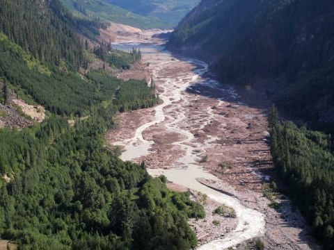
The second-biggest landslide in Canadian history could yet bring flooding to the Lillooet River.
That, at least, is a scenario that isn't dismissed by Jeff Westlake, operations manager for the Pemberton Valley Dyking District (PVDD). He said in an interview that the district is monitoring the river in concert with officials from B.C.'s Ministry of Environment but they have yet to determine what impact the silt will have on water levels.
"That would seem like an obvious case," he said of the idea that silt could build up in the Lillooet and cause more flooding. "The thing is we don't know exactly how much, it really depends on the particle size, how much is being transported downstream and how much of that material will be released within our system.
"Where you have greater gradient and higher velocities in the river, there won't be as much deposition in those areas, but certainly when the gradient flattens out and the velocity is slow, there's a potential for a considerable amount of that material to flow out."
Last Friday saw the Pemberton Valley stare into the face of a potential deluge as a colossal landslide dropped 40 million cubic metres of mud and debris from the summit of Mount Meager into Capricorn Creek, creating an approximately 30-metre natural dam at Meager Creek, with some debris flowing into the Lillooet River.
The entire valley was put on evacuation alert and residents of the Pemberton Meadows and Mount Currie were ordered to evacuate at about 12:30 a.m. on Saturday morning as officials got a better picture of the slide.
Three million cubic metres of water backed up behind the dam before it carved a breach in the debris, allowing water to run naturally into the Lillooet River. There was no major flooding.
The dam and anything backed up behind it are now pushing silt into the Lillooet River, which has lately taken on a murky brown colour. Mud flows into it with the water that's backed up behind the dam.
B.C. Environment Minister Barry Penner phoned Pique Monday and said no additional flooding is expected imminently, as per the observations of geomorphologists who've been watching the slide site. He said, however, that there's a possibility that muddy and woody debris backed up behind the dam could flow downstream in the future.
"We're thinking it could be three to five years before a lot of that material works its way down anywhere close to Pemberton," he said. "That's for the heavier material. For the heavy rain events, that'll start to move some of that bigger stuff gradually downstream. The finer sediments and silt obviously are more mobile and that's why the Lillooet River is such a dark colour today.
"It's heavily loaded with silt right now and probably will continue to be for the foreseeable future."
Though further debris flows are a possibility, Penner said it could take three to five years before woody debris poses a risk to anyone in the Pemberton Valley. During a flyover of the site he said he saw less wood debris than he initially expected and that rainy events could, eventually, move material further downstream.
He wasn't concerned about debris flows in the immediate future but said it's definitely something to think about now.


