
Most people can find Whistler on a map relatively easily. On Google Maps, the name of the town appears after just four clicks over the southwest corner of mainland British Columbia, as well as the names of three significant parks in the region — Clendenning Provincial Park, Stein Valley Nlaka'Pamux Heritage Park and Garibaldi Provincial Park.
Any road map makes it clear that Whistler is located almost due north of Vancouver, the third-largest city in Canada, some 125km up winding Highway 99, also called the Sea to Sky Highway. The first part of the ride hugs the eastern shore of Howe Sound, the second part winds up the Cheakamus Canyon.
But really, where are we?
This is a question that Pique has been wrong about over the years, with occasional references to the Coast Range, Coast Mountain Range and various other geographical place names that are wholly inaccurate. Fortunately, Karl Ricker — a geologist by trade and a geographer, glaciologist, explorer and birder in his spare time — has always been here to set us straight.
We are most certainly not, as we've printed numerous times, in the Coast Range. The Coast Range, explains Ricker, is a low mountain range that runs from California to Washington State, terminating south of the Olympic Peninsula.
Mount Olympus, standing at 7,980 feet/2,428 metres is the highest peak in that area in a range of its own, although it's much easier to see Mt. Baker towering on the horizon when you look south from high places in the Lower Mainland.
Mt. Baker is also not in the Coast Range; it's in the Cascade Range within the U.S. and Cascade Mountains in Canada, which start just west of Chilliwack and extends northward and eastward up the Fraser Canyon to Lytton, and southward to culminate in northern California, just south of Mt. Shasta. But we digress.
Whistler, to be accurate, is within the Western System of the Canadian Cordillera, in a major range known as the Coast Mountains. The Coast Mountains stretch some 1,600km from the Haines Highway in The Yukon, along the eastern edge of the Alasakan Panhandle and south to the Lower Mainland. It's divided into three subranges: Whistler is in the Pacific Ranges, bordered to the north by the Kitimat Ranges which extend from the inlets leading to just beyond Prince Rupert. Farther north are the Boundary Ranges, beginning at Portland Inlet and running northward along the B.C.-Alaskan boundary — hence its name.
But the divisions don't end there; there are more subdivisions to consider. All of the peaks to the north of Fitzsimmons Creek and south of Wedge Creek are considered to be in the Spearhead Range, while all of the peaks to the south of Fitzsimmons Creek are in the Fitzsimmons Range — and beyond both to the southeast lies the McBride Range, named after a famous B.C. Premier, Richard McBride.
Interestingly, these ranges don't include the peaks around Howe Sound like Mount Garibaldi and Cloudburst — they're in an area known as the Southern Fiord Ranges, a name given to the western peaks in the Coast Mountains that are enclosed by fiords. So, for example, Sky Pilot Mountain behind Britannia Beach lies in the Britannia Range of the Southern Fiord Ranges. Got it?
What separates all these ranges? In a word, "physiography", or physical geography. Said Ricker, "Physiography is the classification of mega land forms, and delineating where the boundaries are between them."
Physiography is based on geology, geography, climate, oceanography and other factors that make one area different than the areas it's adjacent to, all the while adhering to a system of definitions to ensure things are named properly. It's why Howe Sound is a true sound as far as Porteau, but is actually a fiord the rest of the way north to Squamish. It's the reason why the Colombia Mountains are not part of The Rocky Mountains, and why Whistler and Blackcomb are in two distinct subranges.
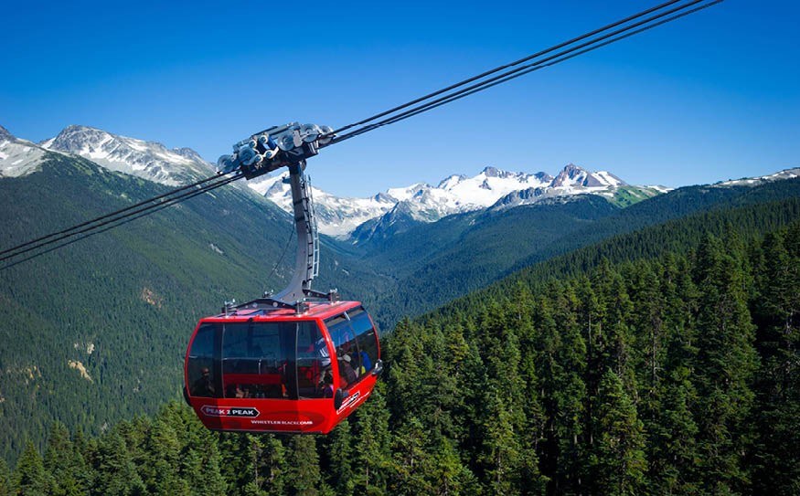
Joined as they may be by the Peak 2 Peak Gondola, Blackcomb Mountain is in the Spearhead range and Whistler Mountain — as well as Overlord Mountain at the end of the traverse — is located in the Fitzsimmons Range.
While the two mountains are right beside each other, the two ranges have very different ages and geologic histories.
"Spearhead is mainly granitic rock, brought up through a mighty fault system that is occupied by the Fitz Creek Valley," explains Ricker. "The Fitzsimmons Range exposes various kinds and ages of volcanic rocks deposited on the sea floor and brought to the surface."
Sediment on the sea floor was compressed into stone under the weight of underwater lava flows, which is why Whistler has more pronounced shale slopes. The reddish colour of the rock in the area around Fissile is brought about by the oxidation of iron-bearing minerals in the rocks, as shown on part of Flute Summit — at one time a hotspot to prospect for metallic minerals.
The aging of mountains is difficult, says Ricker — "Do you measure when the rock was formed, or from when it started to be exposed out the ground" The crystallization of granitic rock in the Spearhead Range is younger then the time of deposition of sediments and volcanic flows at Fissile Mountain.
Although, hold the phone, the Fitzsimmons Range has two distinctly different age groups depending where you look, with older rocks around Fissile and Overlord and younger rocks west of Singing Pass, on the "musical bumps," and on Whistler Mountain.
How the Fitzsimmons and Spearhead ranges formed is related to plate tectonics — specifically to the precursors of the Juan de Fuca Plate (several "splinters" off the northward-moving Pacific Plate) pushing that way eastward under the North American Plate. Those movements are responsible for all the folds, faults, volcanic activity and other ground-lifting pressures that formed mountains along the coast.
Age-wise, the older mountains in this region are on the young side, about 170 million years old according to Natural Resources Canada. Comparatively, the Appalachian Mountains on the eastern side of North America are about half a billion years older.
There are lots of unique geological finds in the region, but Ricker's favourite is a rare and active rock glacier that has formed beneath Disease Ridge, an out-of-bounds area bordering on the 7th Heaven area of Blackcomb.
"What happens is that that rocks tumbled off the face of the ridge and down onto the basin below where there is alpine permafrost — which means any ground that is below zero degrees Celsius for more than one year," he explains. "The rocks kept piling up and the permafrost is kept below freezing because of the protection of those rocks from the sun. The permafrost slowly rises into the pile of rock, while moisture seeps down through the rocks and creates a thin layer of ice around the blocks of rock so they act like giant ball bearings. The rock glacier slowly moves (as more weight is placed on top by falling rock).
"It's not moving very fast, about 15 to 20 centimetres a year, which is normal for a rock glacier. There are some in The Yukon that move up to a metre a year, but it really depends on how much material falls off the ridge.
"What's so unusual is that this damn thing faces south into the sun, which is the last place you'd expect to see a rock glacier. In my mind it's one of our best, unique geological features here by a long shot."
While Ricker is strict when it comes to placing Whistler in the Coast Mountains, he's less particular — and less comfortable — when it comes to the debate about whether Whistler is in a valley. Although it's common to use the phrase "Whistler Valley," technically it's not correct.
"Well, we're between drainage systems, so we are technically a low pass," said Ricker.
The waters in Nita Lake flow south into Alpha Lake and, via the Millar Creek wetlands, into the Cheakamus River, later joining with the Squamish River before spilling into Howe Sound. Alta Lake flows slowly north into Green Lake via the River of Golden Dreams, and from Green Lake into the Green River, over Nairn Falls, around Big Sky Golf and Country Club and the Pemberton Airport before draining into Lillooet Lake, Harrison Lake, the Fraser River and, eventually, the Strait of Georgia — part of a newly recognized body of water called the Salish Sea in recognition of First Nations.
In valleys, water generally accumulates from different sources but runs out in one direction — although there are a few "through" valleys, says Ricker, like the Rocky Mountain Trench. If you stretch the definition slightly and count Whistler as one section of a continuous valley that extends north and south, Ricker allows that we could call Whistler a "through valley," and still be somewhat correct.
As for the area's volcanic history, there isn't much in the way of active volcanoes in the region although there are hot springs and earthquakes in some areas, like Mt. Cayley and Mt. Meager that show volcanic activity below the ground.
There's a local cluster of volcanoes that starts around Mount Garibaldi and heads north and west through the Callaghan and terminates in the Silverthrone- Monmouth Mountain areas.
The most recent eruptions in the province were around 300 years ago. An eruption of the Mt. Tseax lava cone reportedly killed up to 2,000 First Nations in the Nass River Valley with poisonous gas, smoke and hot fluid lava
Some of the local volcanoes in a region known as the Garibaldi Volcanic Belt include Black Tusk and Mount Fee. Some of the eruptions are one to two million years old, but Mt. Garibaldi is as young as 13,000 years, blowing through the ice sheet that covered this entire area some 10,000 to 20,000 years ago.
"Recent" volcanism has little to do with most of the metallic mineralization in the region, or its attraction to miners. Most likely it's a result of older plate tectonic processes, with older seafloor volcanic activity producing minerals like gold, silver, zinc and iron.
One of the more ambitious mining plans for Whistler, which started in the early 1900s, was to mine local bogs, distinct for their orange colour, for iron that was carried down the side of our mountains by runoff.
"It probably didn't amount to much, but they tried anyway," said Ricker. "This place has always been interesting to miners. (Volcanologist) Dr. Jack Souther suspects that there is a significant ore body underneath Flute Mountain, with its deep, orange colour."
So, to recap — the Coast Range and Coast Mountain Range do not exist in B.C. and certainly not in Whistler. The Coast Mountains and Pacific Ranges do, as well as local ranges like the Spearhead and Fitzsimmons. Whistler is not a true valley, either, but we can fudge that without having to rename a dozen different businesses and change the way we talk about our town.


