
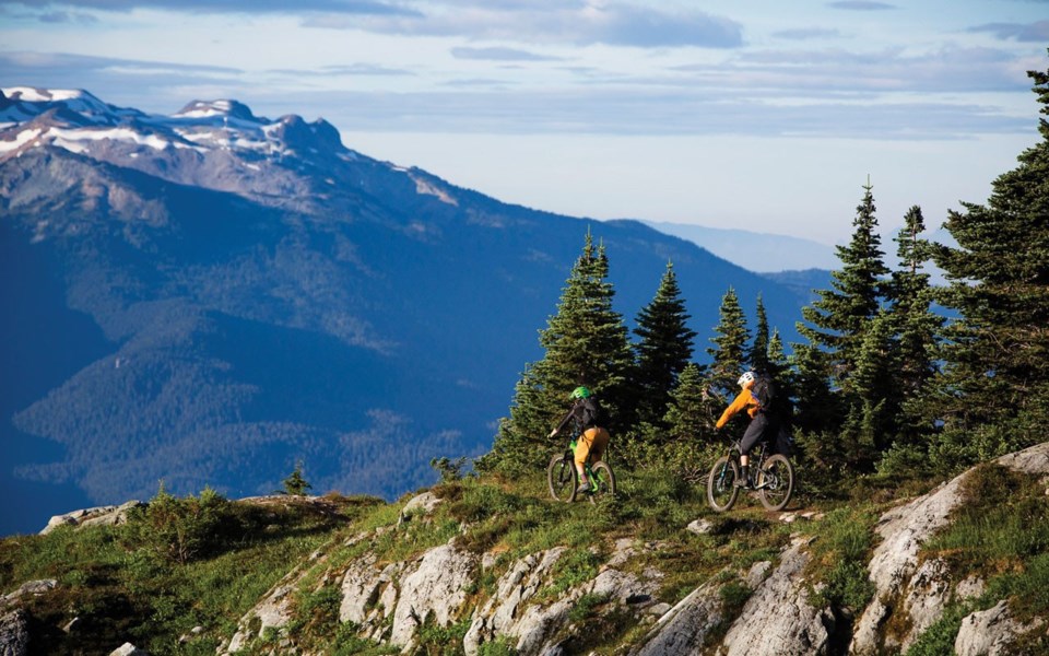
While Whistler's Alpine Trail Network—consisting of backcountry hiking and mountain-biking trails on Mount Sproatt and Rainbow Mountain—opened to the public to much fanfare in 2017, by the following summer, parts of the trail network were closed after two separate groups had run-ins with grizzly bears.
Since then, the Resort Municipality of Whistler (RMOW) has been working backwards to correct the problem.
"We built trails up there without really understanding the use of the area by bears. I think if we could do it now, we would do things differently," said environmental stewardship manager Heather Beresford in a presentation to Whistler council on April 7.
"We made a commitment as a municipal council a number of years ago to support the restoration of grizzly bears in the area, and so we have to do the best we can now."
The network consists of almost 40 kilometres of trails, and in the summer of 2018 there were about 2,500 users per month (for a total of about 14,000 users through the summer/fall season).
And the grizzly presence in the area is growing, with about eight adult grizzlies now living in the Callaghan area, Beresford said.
"It's not that we're going to suddenly be overrun with grizzlies everywhere—it's a slow increase in bear numbers," she said.
"But certainly since 2005, the data that we've had shared with us by the province is showing us that, slowly and steadily, grizzly bears are using more of the area—particularly to the west of our valley—and that we will continue to see them there."
Beresford was on hand for the teleconference meeting to present the RMOW's new human-grizzly bear conflict mitigation strategy, which council endorsed.
Developed in conjunction with Recreation Sites and Trails BC and the Conservation Officer Service (COS), the strategy's main objectives are threefold: identify actions to minimize impacts of recreation on grizzly habitat and use patterns; identify actions to minimize human interactions with grizzlies on alpine trails; and develop a response and communication plan.
While the expansion of the Alpine Trail Network into the Sproatt and Rainbow Mountain area was preceded by a grizzly bear risk assessment and conflict management strategy, an independent review of both documents in 2019 by renowned grizzly expert Lana Ciarniello found some big, unanswered questions.
"Neither of the documents that I read question the effects of the expansion of recreation on grizzly bear habitat or discuss the implication of this increased network on grizzly bears and the conservation of grizzly bears," Ciarniello said in a presentation to Whistler's Committee of the Whole on May 28, 2019. (See "Grizzly plan review reveals unanswered, and unasked, questions,"
Pique, June 3, 2019.)
The RMOW went back to the drawing board following Ciarniello's review, hiring grizzly expert Grant MacHutchon to complete a habitat-mapping project with implications for trail management.
MacHutchon spent about a week in Whistler last fall walking the trails, analyzing different areas and the vegetation—and how the bears were using it—and incorporating collared grizzly-bear data collected by the province as well, Beresford said.
"So there was quite a lot of data that we could overlay with our other [geographic information system] mapping to identify where those collared bears had been using it, and then measure it against what the landscape looked like, and be able to identify hotspots," Beresford said.
MacHutchon came back with some key recommendations: that the RMOW not build trails to Gin and Tonic lakes, or Beverley Lake; reconsider the routing for the Flank Trail south, as well as reroutes for the Skywalk and Pot of Gold trails; install additional signs, information and monitoring, and; continue to ban e-bikes and dogs on alpine trails.
"He recognized there was a key spring grizzly bear meeting area just south of Function Junction [at] a higher elevation above the Flank Trail south," Beresford said.
"There had been consideration of reopening that Flank Trail south into the Callaghan Valley. Knowing what we know now ... is there an alternative route to locate that Flank Trail south? We'll be looking at that very closely this year."
The strategy breaks the Rainbow and Sproatt alpine into three zones, allowing for a staged response rather than blanket closures, Beresford said.
If a bear is in the Skywalk area, for example, "we can focus our response there and not have to close down everything in the whole area," she said.
The Coast to Cascades Grizzly Bear Initiative—which tapped Ciarniello to review the original mitigation strategy—was appreciative of the new document.
"Although ideally this study would have been done several years ago before the alpine trails were laid out and substantially built, it is a good product overall and an important piece of work that provides better information for trail management and planning, and it fills in a number of gaps in the earlier assessment the RMOW commissioned," wrote field director Johnny Mikes in a letter to council.


