
In 1990, Johnny Jones of the Lil'wat Nation took part in a protest roadblock to prevent the construction of logging roads in the Ure Creek region, about 40 kilometres from his home in Mount Currie.
The blockade came after blasting destroyed sacred pictographs depicting legends of the Lil'wat Nation and marking ancient burial sites. The protests had already resulted in dozens of arrests and led to court in an attempt to stop the work. Jones recalled the horror he felt at the destruction.
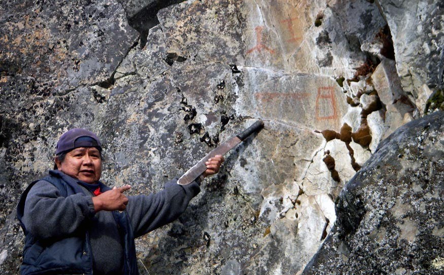
"There were just three pictographs left. A whole rock face of them was blown out. I can't give you a number because there was a whole panel; there were paintings over paintings, all gone. The three left can still be seen: a thunderbird, a deer and what we call the big serpent," he said.
"I didn't have any evidence of those other pictographs (existing) there and the judge threw the court case out."
Fast-forward and the Lil'wat Nation celebrated the creation of three conservancies on March 15, in a signing at Mount Currie that handed over stewardship of 10,000 hectares of wilderness by the British Columbian government.
The three conservancies cover traditional lands — the Qwalímak/Upper Birkenhead Conservancy, K'zuzált/Twin Two Conservancy, and Mkwal'ts Conservancy encompass the watersheds of the Upper Birkenhead River, Twin Two Creek, and Ure Creek respectively, all of which flow into Lillooet Lake near Pemberton. Each has a special designation and purpose, cultural or environmental or a combination of the two.
These decisions didn't happened in a vacuum. They grew out of a very modern protest to protect ancient heritage, and from the use of the most up-to-date technologies of land mapping to gather the evidence needed to make the conservancies a reality.
Geographic Information Systems, or GIS, is a high-tech database that researchers can access to ask questions about the composition of an area of terrain. Using Global Position Systems (GPS) to locate significant areas or objects, the GIS database is one of the biggest tools for Jones — a weapon against future denial of Lil'wat access to the region.
"The judge telling me there was no evidence, that's what got me right into GPSing and mapping all our cultural sites today," he said.
People out in the field collect the data, carrying Trimble handheld GPS in packs on their backs or in vehicles, gathering information as they move around.
"We collect the data and then it's logged into the computer, then the points appear in the maps here. We have the handheld collectors nowadays. It's a lot easier... We pick the points and add notes and hand it over," Jones said.
The information is displayed spatially in a layered map format. A single map can show topography combined with resources, cultural sites, water features, human and animal populations, and anything else considered important.
Originally developed for military applications, the science has been shown to have wider possibilities and is used by governments, business and science.
Now 55, Jones, is the cultural technician with the Lil'wat's Land and Resource Department, but at the age of 10 he got into the world of cartography through a hand-drawn map his grandfather made for him. The map showed spiritual and cultural connections in the region, important locations for food gathering and hunting, where people had lived and died in past times.
Jones expanded on it over time, taking a printed map and adding colour stickers to show places of significance to the Lil'wat. As his project progressed, Jones gathering oral testimony from elders of how land was used. The maps gained a nickname: "Johnny Dot Maps".
"I've always been working on maps in my own time and way. With Johnny Dot Maps there was red for rock paintings, green for culturally modified trees, yellow for cabins or other sites," he said.
In his own words, Jones said he "can still walk around the mountains pretty fast yet," but with the Lil'wat traditional area in question covering up to 778,548 hectares, he saw how the technology ramped up information gathering.
Today, he says he and others trained in the use of the equipment gather "all the information" they can find and hand it on to the Lil'wat's GIS technicians, who plot it.
The Lil'wat GIS maps have been used to respond to requests by proponents of Independent Power Projects, forestry and mining. Jones said it would come into play again should the Pemberton Valley Trails Association be successful in its attemptto get permission to build a trail to the alpine area of Mount Currie later this year. First Nations GIS input will be required at that point, to ensure sensitive areas are not encroached on by the trail.
"Anytime we go out we use it to record information. The fish techs are out now doing that and in a few days I'll be out in a logging block by the Lillooet River," Jones said.
Out of the struggle to protect culturally sensitive areas like Ure Creek from the bulldozer and logging truck, the Lil'wat Nation reestablished their right to have a say in how the land is being used, and this has led to more respect being shown them by industry.
"Oh yeah, yeah. It helps quite a bit, having the GPS and working with the logging companies because now they know the areas to avoid," said Jones.
"After we GPS an area, we flag it out and create a buffer zone around a cultural site. And they move their block away from it. Now they lose half a logging block and they don't mind. At Pebble Creek we saved a whole area in a logging block and deleted it from the logging block. They avoid them, we have a lot of say on that now."
As a further case in point, on April 10 Jones carried out a GPS search of an area following a referral from Halray Logging in Brackendale, to explore a block site before the commencement of logging operations. In his search, Jones and colleagues, including Dave Hall from Arrowstone Archaeological Research, located a lithic scatter site in the area, with evidence of early-flaked stone tool-making activity of cultural and archaeological interest.
Tracy Howlett, who helped start the program in 2005 and worked on it for six years, said initial funding came from Ecotrust Canada to bring the technology in-house.
"Before this, you'd get somebody in to do a project and then all of this information is there and nobody knew how to use it," she said. "This came around the same time the province and the Lil'wat began talking about the Lil'wat Nation Land Use Plan. They knew they needed a lot of maps done."
Howlett said her job was to create the GIS program from the ground up, including buying software and hardware and compiling data and training.
"The first big project was support the full Lil'wat Nation Land Use Plan," she said. "Over the following five years we maintained that project, worked with Johnny and we sent a whole bunch of guys out for GPS training. That was Johnny's first time to go out into the field with his little GPS unit and now he's never without it!"
Howlett says others are also benefiting, with the Haida Nation and the Tsleil-Waututh also following the Lil'wat program to varying degrees.
"And it helped us reach out to our neighbouring municipalities and regions. The Village of Pemberton and the SLRD didn't have a full-time GIS at the time, and so not only was this information we shared with them, we also ended up creating a little outreach and training program!" she said.For Jones, GIS even increased his already solid understanding of the history in the territories.
"It changed a lot since back in the 70s; a lot of the stuff was handwritten on paper. Now we can get three or four metres away from a cultural site and you know exactly where they are. I feel like it's totally awesome," he said, laughing."We'll continue using it and other people will be trained into it, too."

