
Story and photo by John Masters
Meridian Writers’ Group
BERLIN—Except for
six sections, the Berlin Wall is gone now, torn down in 1990, soon after it
toppled along with the Communist East German government that built it.
Much of its erratic,
155-kilometre route across Berlin can still be easily traced to see where it
divided neighbourhoods and severed arteries. But for most visitors there’s no
need to do it all; one short stretch will give you the flavour: Bernauer
Strasse.
To get there, take the
S-bahn to Nordbahnhof station. The station itself is part of the story: during
the 28 years the Wall stood, this was one of 16 ghost stations, sealed off
because the tracks ran into West Berlin.
When you exit the station
you’re at a right angle where the Wall ran north and east. Walk east along
Bernauer two blocks and you reach the Berlin Wall Documentation Center. You
can’t miss it, because just across the street is an 80-metre-long section of
intact Wall.
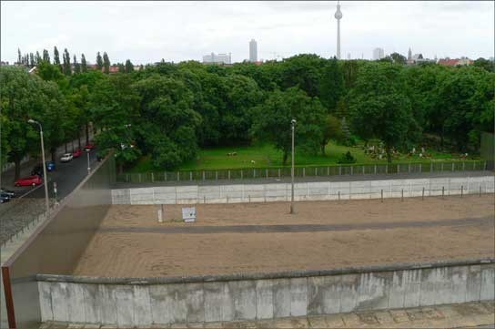
The view from the
documentation centre observation deck makes clear that this was much more than
a simple cement barrier. It began that way in 1961, but over the years it was
refined until it was a 50-metre-wide “death strip” that included barbed wire,
ditches, floodlights, guard towers, dog runs and a chain-link fence. The last
bit, before the cement wall, was open ground to give border guards a clean
shot. Hundreds died trying to make it across.
Inside the documentation
centre the displays explain how the East German government put the Wall up without
warning on Aug. 13, 1961 to prevent any more of its citizens from leaving for
freer, more prosperous West Germany. (Some 30,400 people fled from East to West
Berlin in July 1961 alone.) The exodus was ruining East Germany’s economy. The
government called it the “Anti-fascist Protective Wall.”
In Berlin it followed the
quirky boundaries, drawn up at the end of the Second World War, that divided
the conquered city into four sections, controlled by Britain, France, the
United States and the Soviet Union. It was the Soviets’ section — nearly
half of the city — that became East Berlin.
Bernauer Strasse became
one of the most dramatic examples of how absurd — and lethal — the
Wall was. Here, the dividing line was the street’s south sidewalk. The
buildings on this side of the street were in East Berlin, but the moment you
set foot out the door you were in West Berlin.
In the early days of the
Wall, only the doors to these buildings were sealed, the windows weren’t.
People hung and jumped to freedom, or leaped into nets held up by the West
Berlin fire department. Some missed the mark and died.
Eventually, the windows
were bricked up, then the buildings torn down to make the death strip. Today,
most of the south side of Bernauer around the preserved section of Wall is
still empty land, unfenced and overgrown, a wound from which the city continues
to recover. You can still see the dog runs in places — but now they’re
used by people walking their dogs.
ACCESS
For more information on
the Berlin Wall Documentation Center visit its website at
www.berliner-mauer-dokumentationszentrum.de
.
For more information on Berlin visit the Berlin Tourism website at www.berlin-tourist-information.de .


