
Responding to some concerns shared by one of his post-doctoral students, Canmore resident Dr. John Pomeroy was driving around town at midnight as Wednesday rolled into Thursday, June 20.
As director of the University of Saskatchewan's hydrology department and Canada research chair in water resources and climate change, Pomeroy and his team have been maintaining streamflow and snowmelt research sites in Kananaskis Country for the past decade. Located 45 minutes' drive east of Canmore, the researchers' sites were established by Canada's federal government in the 1960s then shut down in the 1980s.
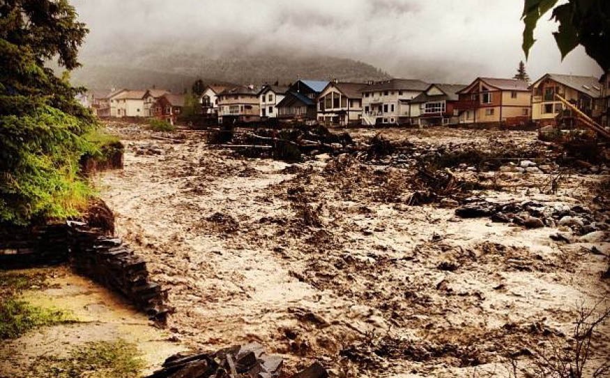
"I wanted to see what was happening at Cougar Creek, so I went to the upper and lower parts within Canmore," Pomeroy said. "I had suggested recently that it was at high risk and knew that the storm was massive and so likely to cause flooding."
Fortunately, the Town of Canmore already had diggers moving boulders in place in an effort to channel the rapidly rising Cougar Creek flow.
It might almost seem ironic that as Colorado residents struggle through intense and destructive forest fires, the storm that flooded Canmore and a massive swath of southern Alberta originated in that U.S. state.
Sucking up warm, humid air from the central US, the storm travelled north then stalled around the Montana/Alberta border. There it rotated counter-clockwise, trapped between the Rockies and a high pressure system to the north, and so its winds blew toward the west — opposite the prevailing direction. This forced the clouds to rise and cool, which then squeezed the moisture out of them — an event known as a "cold low".
"Cold lows cause most floods in the Alberta foothills," Pomeroy said.
Conditions on the ground added to the destructive force of the storm in several ways. Since rain had already fallen for a couple of days previous to the storm's arrival, the soil was saturated. In some places frozen ground was recorded just 50 centimetres down that was unable to absorb the rain. Also at higher elevations, plenty of the winter — and late spring — snowpack remained. Once the rain fell on the snow, the relatively warm humid air associated with rain condensed on the snowpack and released large amounts of energy which melted the snow very rapidly. Strong winds (felt as far as Golden, B.C., two hours' drive northwest) helped this process.
At the same time, the rainfall from the storm was unusually heavy for the Rockies. As it fell on quickly saturating and/or snow-covered slopes, gravity pushed the water overland, creating new channels with enough force to take enormous obstacles with it — from boulders to old-growth trees to backyard sheds and hot tubs, and downstream from Canmore, even houses.
But, while Cougar, Carrot, Stoneworks and Exshaw creeks all flooded, the Bow River did not flood in Canmore, Pomeroy pointed out. The intense rainfall however, did raise groundwater levels, flooding parts of central Canmore.
By the time Alberta Environment issued a flood warning at 8:45 a.m. for tributaries of the Bow River upstream of Calgary, including Cougar Creek, residents whose houses were on the verge of tumbling into the massive, raging torrent had fortunately been evacuated by the town more than three hours earlier.
"The town was on the spot," Pomeroy said. "But there are no weather stations or stream gauges in the Cougar Creek watershed and there are relatively few high elevation stations around it. As a result, there is limited capacity to monitor what's happening in tributaries such as Cougar Creek. There was no direct information on what was coming down the creek."
Despite the fact that hundreds of houses have been built on the Cougar Creek alluvial fan in the last 25 years, and that the country's main transportation corridors, the TransCanada Highway and the CP Railway cross directly in its path, neither the Province nor the federal government maintain any real-time gauges in Cougar Creek — or many other equally significant tributaries of the Bow River.
By extension, there was no information coming from upstream on Exshaw Creek, Carrot Creek, Three Sisters Creek or Stoneworks Creek either.
Add to that, Alberta's government has been dragging its heels and shelving studies and recommendations concerning flood-related research and mapping for decades. Successive Alberta governments have not just permitted, but encouraged building on flood plains — or in the case of Cougar Creek, alluvial fans.
"It [flooding] was guaranteed to happen," Pomeroy said. "It's been happening there for the last 10,000 years. It's all alluvial fan."
Building in flood plains is irresponsible, Pomeroy said, adding that as climate change is predicted — and is already creating — heavier rains, more precipitation falling as rain instead of snow and rain falling on top of snow, patterns that are different to what we've become accustomed to enjoying over the past 100 years, flood awareness and mitigation are becoming increasingly crucial priorities.
Alberta, he said, has simply not been built to accommodate future — and obviously present — climate conditions.
On top of that, Canada's federal and provincial governments have not established adequate coordinated weather and climate-related information gathering and sharing.
"It would be good if they worked together in a more coordinated manner to ensure integrated weather and flood forecasts, updated mapping of flood plains, increased flood defenses along vulnerable creeks as well as the big rivers, and implemented multiple objective reservoir management so our dams are operated for flood protection as well as hydroelectricity, and dealt with the causes of climate change in a more effective manner," Pomeroy said.


