
Welcome to Fiordland, B.C. Population: Countless. Unless you're counting humans, in which case the population is sparse, rugged and fiercely independent, as befits the land, er, water. Fiordland is termed a recreation area. I won't argue with that except to say whatever recreation it offers is inexorably tied to watercraft. Without a detailed examination of the charts and repeated application of Pythagoras' theorem, I couldn't guess the proportion of water to land in Fiordland, but I would hazard a guess it is both substantial and irrelevant. What land there is — largely vertical — is accessible only by water or flight and the water is a long, long way away from all but the most sparse, outlier roads. I'm sure Google could tell me the exact proportions but I haven't been able to hail it for over a week.
There are times uncertainty lends an air of mystery to things and this is one of those times.
Fiordland is mysterious.
Chief among its mysteries is why it's spelled Fiordland instead of Fjordland since fjord is the only spelling of that peculiar body of water I've been familiar with. One local I stumbled — floated — across suggested it may have something to do with an international tiff Canada got into with the Norwegians over import duties on herring or something like that. Judging from the twinkle in her eye when she told me this nugget of forgotten historical trivia, I suspect she had no more substantial insight into the mystery than I but I admired her pluck, answering stupid questions from people obtuse enough to ask them.
Fiordland is a labyrinth of, well, fjords, narrow fingers of water that maze in and around the countless islands and mainland shoreline of British Columbia north of Bella Bella and south of Lizette Lake. According to the charts, vast mountains rise over 3,000 feet — you do the conversion; many of these charts predate Canada's adoption of metric and employ a quaint, seafaring mix of feet, knots, fathoms and metres — directly from the water. The fjords themselves plunge in an unbroken plane from the pitch of the land, leading to the heightened sense of doom I feel when we nudge a very expensive boat we've promised to return unbroken and unsunk within metres of unforgiving rock, salved by a depth gauge that says we're still in 30 metres of water, having only metres earlier been in 180 metres of water.
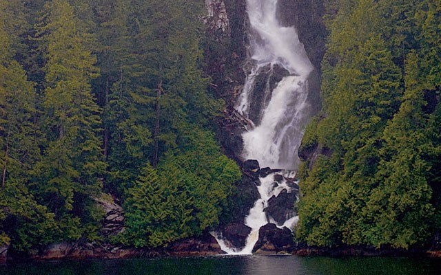
They say bold sailors can come close enough to many of the countless waterfalls to simply reach out with a funnel attached to a hose and replenish their fresh water supply. None of the bold sailors I've ever spoken to have tried this act of desperation, but to a man and woman all have heard of it. Lore of the sea is the watery equivalent of urban myth, I suspect.
But getting back to the 3,000-foot pinnacles, I can only assume the charts are accurate. From personal observation I can only attest to the first 300 or so feet since that is more or less the level of cloud, cloud being a guess on my part since the fog starts inches above the water and rises, unbroken, to a height where the dark silhouette of land disappears in a milky whiteness. Adding to the disorientation is, of course, torrential rainfall.
We are steering only through the graces of electronics. Radar keeps vigil ahead, lest we encounter another vessel. It sees — we hope — several nautical miles distant; our eyes see several dozen metres before they begin to hallucinate large, fast cutters on a collision course.
Our chart plotter, guided by the invisible hand of eight or so global positioning satellites, displays our exact position and, more importantly, the exact position of things that are capable of destroying the hull of our boat and creating a very embarrassing situation, assuming we don't drown and eventually do have to explain to the charter company why their boat sits 250 metres down at the bottom of some fjord or another.
Another position plotter — there's an app for that — plays a redundant role as backup, tracking our movements on an iPad sitting next to the much more sophisticated, read expensive, chart plotter. Being thoroughly modern people, we seem to rely on it for the most part.
Waypoints strung together like patio lights describe our route and the electronic chatter between the chart plotter and the Smart Pilot™ and the doodads — nautical term of art — hooked up to the rudder steer a true course to our destination while we sit back and wait for Trump and Putin to get so pissed off at each other they unleash space weapons and destroy the GPS system, reducing us to relying on those paper charts, a compass and the deep collective memory of our captain... who can't seem to remember where he left his coffee mug.
Still, I am in awe of those who have been this way before. Before chart plotters. Before GPS. Before autopilot. Before charts!
Captain George Vancouver was here. We're following his course today in places named by him. He not only didn't have any of our electronica; he didn't have an engine. Somehow he steered his ship through these waters under sail... with able lookouts... depth sounding lines... perhaps the grace of God.
Mussel Bay and Poison Cove come near to describing one corner of Fiordland. A marshy, broad river delta lies at the end of Mussel Bay, as do, presumably, numerous mussels. Two days before summer solstice there is still avalanche debris at the foot of the large, bald mountain and its thunderous waterfall. Captain Vancouver was here and here his crew collected and feasted on mussels.
To the east lies Poison Cove, another deep albeit small fjord draining the other side of the same bald mountain. It's not unreasonable to hope to find spirit bears here although we only see stump bears. It was in Poison Cove that Captain Vancouver lost several of his crew when they died from eating contaminated mussels. It seems red tide long predated pleasure boaters with faulty holding tanks by several centuries. We take a pass on the mussels and observe a moment of silence in awe and admiration of the captain and his crew.
The weather is foul but the place is magnificent, punctuated frequently by stunning waterfalls. And it's somehow totally appropriate the weather is foul in this isolated, gloriously wild place. While Captain Vancouver gave his name to the city most everyone in the world associates with British Columbia, it is places like this that, in a very real sense, define it. Floating through them, seeing the rain, feeling the cloud, hoping for a bit of sun, it's not hard to think of the meaningless distractions and petty differences embodied by the city named after the captain whose jubilant crew ate mussels and died in this very spot.
Sail on.


