
CANMORE, Alta. — Another wildlife overpass is being planned for the Trans-Canada Highway, this one east of Canmore, near the entrance to Banff National Park.
Six overpasses and 38 underpasses designed for wildlife passage have already been completed in the 82-kilometre section of the highway from the park entrance near Canmore to the Continental Divide. Neighbouring Yoho National Park also has one underpass.
In addition to the wildlife overpass, an electric detection system that would sense wildlife movement, triggering messages on nearby signs, is being planned, according to the Rocky Mountain Outlook.
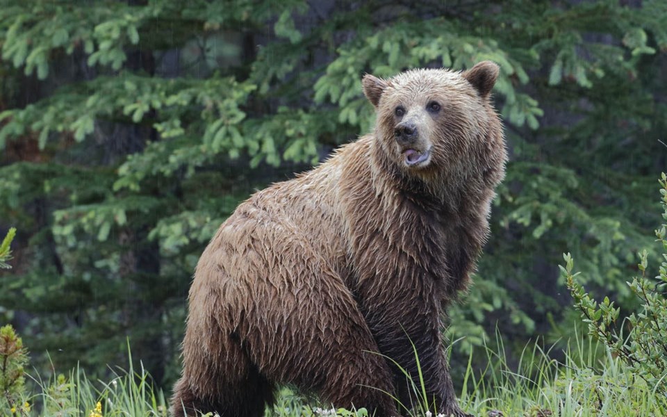
Grizzly bears are among the wildlife species expected to benefit if the overpass is built. A new study of use of overpasses and underpasses in Banff National Park found that grizzly bears select larger and more opens structures like overpasses and open-span bridges, compared to tunnels and culverts. The study, published recently in the Wildlife Society Bulletin, also found that a mother bear with cubs opted to use an overpass instead of an underpass in almost every case.
"Highway mitigation that does not address the passage needs of breeding females is not highway mitigation," said Tony Clevenger, a renowned road ecologist based in Canmore. He is affiliated with the Western Transportation Institute of Montana State University.
"In order to ensure that we've connected the population genetically and demographically, we've got to get breeding females across these highways if they're going to be viable over the long term."
Clevenger went on to say that a large number of overpasses are not needed. "There's got to be a range of other structure-types that are smaller, but one or two overpasses there are critical, especially with this expanding grizzly bear population."
Might highway mitigation be stepped up in the United States? The Outlook reported the U.S. Interagency Grizzly Bear Study Team is paying close attention to the research at Banff with an eye toward mitigation needed for highways between Banff and Yellowstone National Park. There have been mitigations along U.S. Highway 93, which extends from Arizona to Banff, but not in the I-90 and I-15 corridors as they cross the Rockies.
Sunshine and warm days no friends to skiers or firefighters
TAOS, N.M. — Sunny skies were forecast for Taos yet again this week, a town and a ski area that desperately needs snow days.
The situation is sufficiently dire that last week Lorenzo Trujillo, in a letter published in the Taos News, proposed that the town council appeal to the Taos Pueblo Elders to see if there is a snow or rain dance ceremony that could be done.
Actually, members of the Taos Pueblo did perform such a snow dance at the Taos Ski Valley in early December. Maybe a second time is the charm?
Taos has lots of company across the drought-stricken West. In a general way, common in La Niña years, those to the north have fared better than those to the south.
Even in Colorado, ski areas just a few hundred kilometres apart have dramatically different situations. Summit County was close to average, even before this week's snow. Snow helped southwest Colorado, where Telluride on Tuesday reported 30 centimetres of snow in 12 hours.
But as of late January, local river drainages in the San Juan Mountains were just 34 to 36 per cent of average. Farther north, near Grand Junction, the Powderhorn ski area cut back its operations to Thursday through Sunday, to better conserve snow.
"There are some parts of the state that are in dire situations," said Jim Pokrandt, of the Colorado River Water Conservation District.
California has it tough, too. At Phillips Station, south of Lake Tahoe, hydrologists last week found just 13 per cent of average snowpack, reported the San Francisco Chronicle. Only twice since record keeping began in 1946 has there been less snow: 2014 and 1963. No skis were necessary to get to the site; boots were sufficient.
The problem lies off the shore of California in the form of what climate scientist Daniel Swain of the California Weather Blog called the "strong, persistent, broad and anomalous ridge of atmospheric high pressure." Several years ago, he coined it the "ridiculously resilient ridge."
In a Feb. 1 posting, he reported a snow drought across most of the mountainous interior of the American West caused in part by below-average precipitation but more importantly by above-average temperatures.
It's been sizzling in Southern California. Daytime temperatures have soared above 32 C, overnight lows stayed above 21 C. In the Sierra Nevada, the temperature range was different, but the band of temperatures was also anomalous.
Swain predicts that the ongoing warm and dry spell will likely melt what little snow currently exists below about 2,400 metres in elevation.
Base elevation of Northstar is 1,900 metres; Squaw Valley 1,890 metres; Heavenly 1,900 metres. Mammoth is at 2,700 metres, although the town centre is 2,280.
Swain warns against expecting the atmospheric high pressure to dissipate before mid-February — and maybe not then. "It's still possible that a robust storm sequence in late February (or another "Miracle March") could bring a remarkable turnaround in short order. But while that possibility remains on the table the odds are long."
In New Mexico, there are already questions about potential for forest fires. If the past is a prelude, this could be a tricky year.
Dr. Ellis Margolis, a research ecologist, has studied tree rings and photographs of aspen stands, which commonly appear after major blazes, in assembling a history of fires in the Taos area during the last 400 years.
He found that about 90 per cent of the fires broke out in spring and early summer, usually in a drought year. Often the drought year or years had been preceded by wet conditions in prior years, which likely promoted the growth of surface fuels that helped the fire to spread.
Last year was a wet one in the Taos area.
The study also found that recent forest fires, although hot-burning, have not been particularly large compared to those of the past. Those past fires did not necessarily burn down trees.
According to an account in the Taos News, Margolis advises thinning the lower-elevation ponderosa forests along with controlled burns, to reduce the risk of the frequent fires in that ecosystem.
In the sub-alpine forests found at higher elevations, fires are more rare but burn much hotter.
"The challenging part is in upper elevation forests where historically those sub-alpine forests burn in big, hot patches and burn to the ground. Whatever's in the way could be in trouble."
One such community in harm's way is the Taos Ski Valley. Margolis stressed the importance of evacuation plans.
More steps taken to address wildfire risk
BRECKENRIDGE, Colo. — After the big drought year of 2002, public officials in Summit County got wildfire religion. That year the giant Hayman Fire charred 138,000 acres just across the Continental Divide in the foothills southwest of Denver. In Colorado that same summer, big fires howled at Glenwood Springs and north of Durango.
Instead of resisting any and all timber cutting, public officials in Summit County began pushing for selective cutting, began requiring defensible space, began focusing on what is often called the wildland-urban interface. Almost all of the homes in Summit County fall in that category.
Still, there was another fire last summer, when a billowing blaze in the Tenmile Range seemed to be heading straight for Breckenridge. It didn't get there. The weather intervened. But it was a stern reminder that communities of Summit County were vulnerable.
Now, Summit County's government has stepped up the effort to reduce wildlife hazard with the most comprehensive update to the Community Wildfire Protection Plan in 10 years.
The effort began before last year's fire, but Dan Gibbs, a county commissioner as well as a wildland firefighter, said the Peak Two Fire was a "sobering reminder of how real the threat of wildfire is in Summit County. We're very fortunate that the fire didn't make its way into our neighbourhoods, but we have to be proactive in taking concrete steps to reduce our exposure to those types of risks."Wildfire hazards and potential mitigation measures must be assessed when updating master plans and as part of any new rezoning, planned unit development, or subdivision application.
New landscaping regulations promote a more wildfire-resilient community through defensible space requirements. The changes also address the placement of combustible materials, such as wood fencing and firewood piles, which can indirectly lead to home loss from wildfire.
"We arrived at these changes through a rigourous review and analysis by numerous wildfire experts, community stakeholders and county representatives," said Lindsay Hirsh, senior planner.Since 2006, more than 150 wildfire hazard-reduction projects have been completed through partnerships among Summit County, the U.S. Forest Service, local towns, residents, and landowners. Other partners in forest-thinning projects include Denver Water and the Colorado Forest Service.
Denver Water last February committed another US$16.5 million to efforts to address forest stands in Summit County, from which it draws water for metropolitan Denver.


