
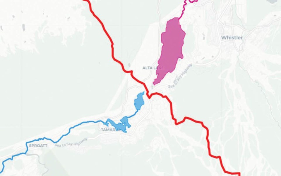
The section of the Valley Trail between Nita Lake and Alta Lake is known as Whistler's watershed divide between Squamish and Lillooet. There isn't much to see from the ground, but it's the view from above that is the most revealing.
A drop of water falling slightly to the south of this point will travel 60 kilometres downstream and eventually drain to Howe Sound through Miller Creek, the Cheakamus River and then the Squamish River.
However, a drop of water that falls slightly to the north of this point will embark on a 330 km journey through the Green River, Lillooet River, Harrison River and Fraser River, eventually making its way to the ocean on an entirely different route.
Watersheds and drainage pathways are an effective means to conceptualize connectivity between aquatic and terrestrial ecosystems. Just about everything we do on the landscape will be felt in streams and lakes through runoff, erosion and related hydrological processes.
For example, large-scale clearing of trees may increase peak flows in the spring or decrease low flows in the summer.
Runoff from urban areas, roads and industrial sites may carry contaminants such as heavy metals. Intensive development adjacent to streams will influence water temperature, along with a suite of other attributes.
However, just like the Valley Trail junction between Nita Lake and Alta Lake, it can be difficult to make sense of drainage pathways for a given location. Runoff sources may be kilometres away and therefore connectivity between these processes can be better understood with a view from above.
Although we often think of watersheds and drainage pathways in the downstream direction (i.e., contaminates and runoff), it is also important to consider connectivity going in the upstream direction.
One of the biggest drivers of fish distributions is the accessibility to waterbodies and barriers to upstream fish passage. Although Alta Lake drains primarily to the north, through the River of Golden Dreams, there is still some southern seepage into Nita Lake. It's possible that (historically) a south outlet to Nita Lake from Alta Lake could have been larger, prior to early rail development. But it's unclear when (or if) this route was ever passable to fish.
Upstream connectivity is also essential for understanding population viability and mitigating the spread of aquatic invasive species.
Similar to knowing our way around local trails, it's also important that we understand how water moves through drainage networks. This knowledge can enable us to make more informed environmental stewardship decisions.
Try asking yourself if you can trace out the path a drop of water will take from your current location to the ocean.
Naturespeak is prepared by the Whistler Naturalists. To learn more about Whistler's natural world, go to Whistlernaturalists.ca.


