
A new project from a team of scientists from Simon Fraser and Quest universities will look at the relationship between warming weather trends and landslides in in the Mount Meager Volcanic Complex (MMVC).
Quest University geologist Steve Quane said there is plenty of anecdotal evidence that suggests slopes in the area fail when temperatures get warm. "What we are trying to do is get the data to be able to show that in more detail," he explained.
In May, two significant landslides occurred on the northeast face of Joffre Peak, in the Cerise Creek Conservation Area, with some pointing to rapidly melting permafrost as the culprit. .
And in 2010, a rock slope above Capricorn Creek in the MMVC failed, forming the largest landslide in Canadian History.
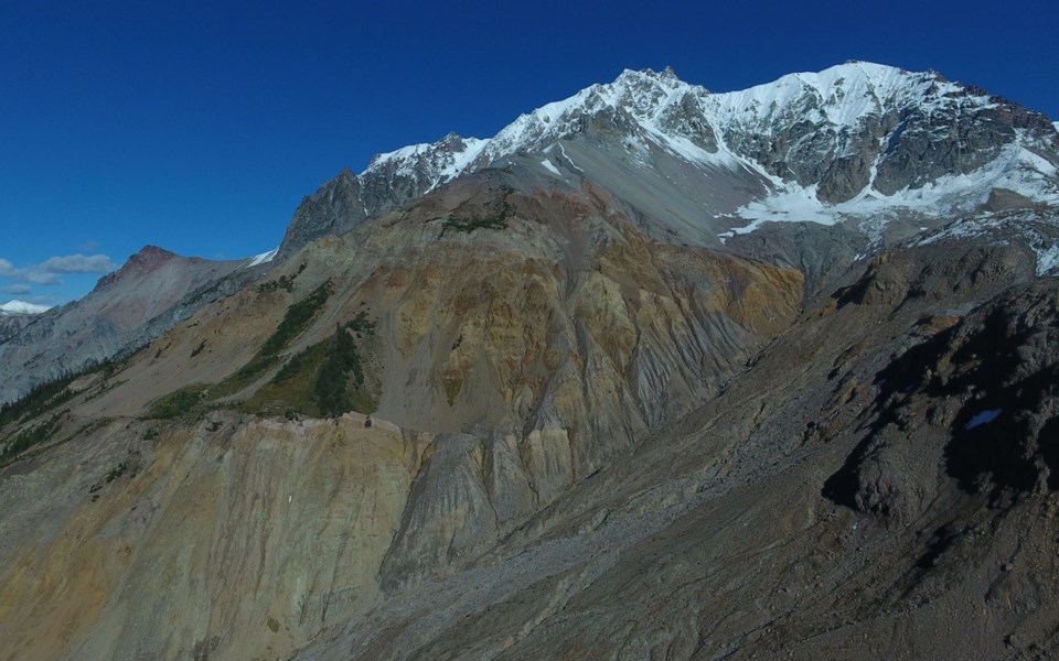
According to Quane, there are multiple slopes within the MMVC at risk of failing, with one of particular concern. The west-facing slope sits on the shoulder of Plinth Peak in a remote area on the border of Upper Lillooet Provincial Park.
It, he wrote in a funding request to the Squamish-Lillooet Regional District (SLRD), has a volume of about 10 times the source of the 2010 slide and is "actively deforming" at a rate of about three centimetres a month during summer months.
"On a geological scale it's pretty [significant]," Quane said.
A slide could lead to flooding of the Lillooet River and potentially reach some homes in the Pemberton Valley, said Quane. There is, he added, a mine and run-of-river hydroelectrical power plant in the area.
Moreover, the beautiful area is popular with hikers, Quane said.
"There is a lot of hunting and summer recreation going on," he said.
The plan, he explained, is to install a geophone (to measure seismic activity), infrasound system (to measure sound waves), a remote camera, and a weather station (to measure variables such as temperature, precipitation, and moisture) at the site.
The equipment will allow scientists to monitor the slope in real time, gaining important insights into the correlation between weather trends and landslides or rock fall.
Quane added that the monitoring system could eventually serve as the basis for a warning system that could alert the public when conditions become dangerous.
"With summer coming faster and the climate continuing to change, I think municipalities and governments are going to need to start thinking about what days are safe to go into these remote areas," he said.
Quane recently requested $5,000 from the SLRD in support of the project, which is also receiving support from two Lower Mainland firms that are pioneers in the creation and deployment of landslide alarm systems and remote camera monitoring.
While supportive of the proposal, the SLRD has since reached out to the Village of Pemberton (VOP) as well as Lil'wat Nation to split the request three ways ($1,667 each). VOP council voted to support the funding request during its Sept. 10 regular council meeting, with Mayor Mike Richman saying that the project presents "a lot of value for our dollar" following the meeting.
"One of the things we struggle with is we manage to get assessments done on some of the geohazards—and you might get some good assessments—but now what do you do with them?" he said, noting the expense.
"We would like to have monitoring of Mount Currie and Mount Meager, but don't have the technical capacity to do that," he said.
Richman said that it's important to understand the issues at play, adding that the Sea to Sky corridor is rife with geohazards.
"Do I think we need to sterilize the valley?" said Richman of the potential danger. "No, but it's good to understand the issue, and that's where the monitoring comes in."
That squares with Quane's description of the monitoring project, which he said could aid the region in future land-use planning.
"As populations grow, we can think about the best places to build—and where not to build," he said.


