
By Jack Christie
Care for a touch of adventure, B.C.-style? Then come stand in a
place that time forgot. Or at least overlooked. Welcome to the Brooks
Peninsula. Mention that name to most Vancouver Islanders, let alone Lower
Mainland residents, and be prepared to draw a blank. Where?
Pinpoint a familiar place, like Tofino, midway up the west side
of Vancouver Island. Head north from there past reefs, shoals, and clusters of
islands large and small in Clayoquot, Nootka, and Kyuquot Sounds. Just before
reaching Vancouver Island’s northern tip, out pops the Brooks, a roughly
15-by-10 kilometre, brick-shaped peninsula renown as one of the wildest,
wettest, and stormiest place on the West Coast. Small wonder this region is
overlooked by all but a few hundred explorers each year, most of who journey
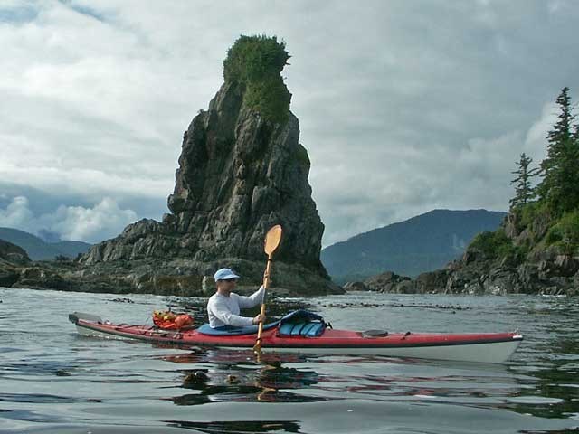
around Kyuquot Sound in sea kayaks during summer months. That suits the
astoundingly-plentiful wildlife just fine, particularly the 400 or more sea
otters which European sailors hunted to extinction in the 1700s and which
scientists have successfully recolonized here since 1969.
During the most recent ice age, which ended roughly 10,000
years ago, glaciers locked most of Vancouver Island in a cryogenic vault.
Brooks Peninsula somehow sidestepped the ice pan. Its steep-sided slopes
remained as green then as now. As a result, rare plant species found refuge
there among its unique geologic formations. And that’s what makes landing on
one of Brooks’ surf-thumped beaches feel like you’ve entered a lost world. For
starters, there’s no one else in sight along the sandy expanses spread between
rocky headlands and dotted with sea stacks. For another, just try to penetrate
the rainforest perimeter that walls the strands. Good luck hacking your way
through an impenetrable morass of mosses, ferns, and deadfall cloaked with
thickets of waist-high salal bushes. One look will convince you of the utter
impossibility of the challenge.
Hidden beneath a jumble of driftwood logs flung inland by winter storms, fresh water gathers on the forest floor and flows out to the ocean in small creeks. In places, cold springs seep out of the rock face and pool near the tideline. When warmed by the sun, bathing in the soft spring water provides welcome relief from the briny Pacific whose swells may have doused you when nosing your kayak ashore.
Centuries-old Sitka spruce vainly struggle to reach heights that match their enormous girths. Brooks’ forests routinely absorb pummellings from winds on a scale that makes the micro-bursts that struck Stanley Park in 2006 look like nibbles on earlobes by comparison. Despite this fierce reputation, pick a week when wind, waves, and weather harmonize, and you’ll find the welcome mat spread out not just along the south side of the peninsula but around almost all of Kyuquot Sound which includes the Checleset Bay Ecological Reserve where sea otters thrive among sheltering kelp beds.
In order to reach the Brooks Peninsula, most of which is now
protected as a 51,631-hectare provincial park, you must first pass through
several groups of islands. Paddlers with campsites in mind will find the most
appealing ones in Big Bunsby Marine Park. In fact, if you’re only exploring for
a few days, the Bunsby group of five major islands constitutes a fine
destination in itself. The one drawback there is a lack of fresh water. The
nearest source is an hour’s paddle away at Battle Bay on the Vancouver Island
mainland. Brooks Peninsula lies a further three hours paddle north of the
Bunsbys.
If you’re pressed for time, the best option for reaching the
heart of Kyuquot Sound is to arrange for a ride on the local water taxi.
Skipper Leo Jack operates the Voyager Water Taxi from his base in the village
of Kyuquot (ky-oo-cut). Jack started his business 13 years ago because “there
was no work. The mining, fishing, and logging jobs are all gone.” Now his days
are busy ferrying groups of kayakers back and forth to drop-off points just
about anywhere in the sound, with the exception of several islands which
require advance permission from the Kyuquot First Nation band office to visit.
Jack provides more than simple transportation. With his guidance, you may well find yourself being steered towards a special place to camp, such as Island 195 in the Bunsbys or a cluster of beaches around Jackobson Point on Brooks Peninsula’s south coast.
Island 195 is so named because of its maximum elevation in feet above the ocean. The diminutive island is the most westerly of the Bunsby group and its white shell beach faces the open ocean. There’s hardly room for more than two tents above the tide line, which makes for an intimate setting from where to survey the nearby kelp beds. Above the roar of the surf which cannons against distant reefs and sea stacks can be heard the mewing of sea otter kits and their mothers who paddle back and forth along a watery highway. Sea otters are surprisingly large, as much as 45 kilos in weight and 150 centimetres long, and are covered in a thick, soft coat which made them such a prized catch centuries ago. Easily spotted, they play, preen, and munch on shellfish as they float lazily on their backs. At night, they wrap themselves in bull kelp tendrils anchored to the ocean floor, which make for secure places to sleep.
Kyuquot Sound boasts an abundance of wildlife that would be the
envy of any national park. Sleek little river otters and black bandit-masked
raccoons, bald eagles and Pacific loons, oystercatchers and belted kingfishers,
as well as the occasional black bear, all work the shorelines in search of
food. Come prepared with good lengths of rope and a pulley to hang your
supplies well out of reach of beaks and paws.
From the vantage point of a sea kayak, gently rocking in the swells, all of this natural activity is gradually revealed as one hour fades into the next, a pace perfectly suited to a place that time forgot.
Access: There are several launch points to begin an exploration
of Kyuquot Sound, including the federal wharves at both Fair Harbour and the
village of Kyuquot. To reach Fair Harbour, travel north from Vancouver via
Nanaimo on Highway 19 to Nimpkish, a distance of about 300 kilometres. From
there, head 35 kilometres southwest across the island to the village of Zeballos.
Fair Harbour, which offers little more than a parking lot, a boat ramp, and a
convenience store, is a further one-hour drive from there. The
MV Uchuck III
sails from Gold River to Kyuquot. To reach
Gold River from Vancouver via ferry to Nanaimo, travel 150 kilometres north to
Campbell River on Highway 19, then 90 kilometres west on Highway 28. The
Uchuck
III
sails to Kyuquot on Thursdays and
returns on Fridays. For rates and schedules, visit www.mvuchuck.com or call
250-283-2325. For water taxi service in Kyuquot Sound, contact Voyager Water
Taxi, 250-332-5301 or visit www.voyagerwatertaxi.com. A detailed description of
kayaking Kyuquot Sound is included in
Kayak Routes
(Peter McGee, Greystone Books). Indispensable marine
charts of the Bunsby Islands and Brooks Peninsula region are 3623 Kyuquot to
Cape Cook and 3683 Checleset Bay, available from the Geographical Survey of
Canada (605 Robson Street, Vancouver; 604-666-0271). Kayak rental locations on
Vancouver Island include Courtenay and Campbell River (www.comoxvalleykayaks.com),
as well as Zeballos (www.zeballoskayaks.com). Tourism Vancouver Island’s
website, vancouverisland.travel, is another valuable resource. For information
on ferry rates and schedules between Vancouver and Nanaimo, visit bcferries.com.
To learn more about Brooks Peninsula Park and Big Bunsby Marine Park, visit
www.bcparks.ca.
Jack Christie is the author of The Whistler Book (Greystone Books). Visit him at jackchristie.com.


