
When Helen Mabey returns to her home on Great Barrier Island from a few days in Auckland, New Zealand — two hours away by car ferry — she’s relieved.
“I can’t get back quickly enough,” says the affable widow who, with two sons, runs 2,500 sheep and 400 cattle near the island’s northeastern Whangapoua Estuary.
We flew from Auckland to this largest of 47 islands in the Hauraki Gulf east of the city, on a Mountain Air nine-seater. As we buckled up, pilot Kelly wiped the steamy cockpit window with a rag. And then, after a Qantas Airways leviathan lumbered off the runway ahead of us, we were off.
Despite cloud, we could see the low-lying volcanic cone that is Rangitoto Island, and Waiheke Island, celebrated for its vineyards and sybaritic lifestyle. To our south lay Coromandel Peninsula on the North Island. We crossed Colville Channel and Great Barrier itself — with its long, curvaceous beaches — landing on a bit of tarmac near the village of Claris.
Roughly 800 people live on Great Barrier, most in this southern region. And that number is falling. Those few who settle here now build a luxury second home in the hills or waterfront. “We used to have a lot of hippies, but they can’t afford to live here now,” Mabey said. Islanders must generate their own power; there’s no cell phone reception.
After breakfast at the Claris café (a platter of eggs, rasher of bacon, and hash-brown patties), and with our guide Stanley at the wheel of a four-by-four, we headed northward along the island’s narrow, winding roads.
Just under 300 square kilometres in size, Great Barrier is largely mountain, semi-tropical jungle and mostly deserted beaches. On the east side the sand is white, on the west of darker volcanic grains.
Maoris have long lived here; Captain Cook named it Great Barrier Island (and Little Barrier to the west) when he sailed into the Hauraki Gulf in 1769. So isolated is Great Barrier Island that it’s had very few natural predators and, with the help of the federal Department of Conservation, exotic birds and other wildlife flourish.
In the island’s centre, off Whangaparapara Road, we stopped at a sign that said Kaitoke Hot Springs, laced up our boots and, as they say in New Zealand, went tramping.
Along the trail we were among flowering Manuka trees and five-metre-high ferns with coiled fiddleheads. We watched a large wood pigeon defecate reconstituted berries (“sounds like ball-bearings,” Stanley said), and heard the cry of the parrot-like caw-caw.
What we didn’t see was the celebrated native kauri tree — a primitive pine once so sought after for shipbuilding and other uses that it’s now almost eradicated.
An hour along the trail, we arrived at a muddy pool in a slow-moving river. The hot springs felt tepid. “If it smells bad it’s usually hot,” Stanley said. “You can use your nose to find the hot spots.”
Back on the road, a yellow sign asked drivers to watch out for an endangered nocturnal duck, unique to Great Barrier Island, called the brown teal. Then from the eastern cliffs, we descended into the swamp-like Whangapoua Estuary, passed through the hamlet of Okiwi (nary a house in sight), and eventually slipped down a steep slope to Mabey’s home.
A cluster of Norfolk pines — a native tree that resembles an outsized menorah — towers in front of the cottage that was once sheep shearers’ living quarters. Beyond stretches Whangapoua Beach. Beyond that a rock called Arid Island rises from the ocean like a forbidding monolith. And beyond that — quite a way — is Chile.
A hearty lunch included hot fish pies of the red snappers that Mabey had caught off nearby rocks. “It was low tide at half-past seven,” she said. “I was back at half-past eight, and put them up in the cookhouse.”
The Mabeys ship their livestock to urban markets. “There’s no money in wool anymore, but you still shear the sheep — it keeps them healthy,” Mabey said. “We sell lambs. Wean them off their mothers. Lots of work sheep. We used to have 33 million sheep in New Zealand. Now there’s about half that number.”
From the cottage we walked down the deserted beach to a rocky headland called Waikaro Point. In 1892, a luxury steamer, the SS Wairarapa , carrying passengers and crated horses, ran into these cliffs in fog.
In one of New Zealand’s most profoundly felt maritime disasters, 155 passengers and crew drowned. Local Maoris collected the bodies. A graveyard on a grassy ledge above the beach, framed by a white picket fence, holds many of them.
It took three days to get word of the tragedy to Auckland. As a result, a pigeon mail service was established, said to be the first “air mail” in the world. Birds were used until 1908, when a telephone link was established.
From northeastern Great Barrier Island, we drove to the west shore and Port Fitzroy. In summer this sheltered harbour hosts hundred of “yachties,” the Kiwi name for people who sail. On a green slope above this bay stands a handsome historic house made with wood of the almost extinct kauri tree. This house, and surrounding land, is owned by one of New Zealand’s most celebrated yachtsmen.
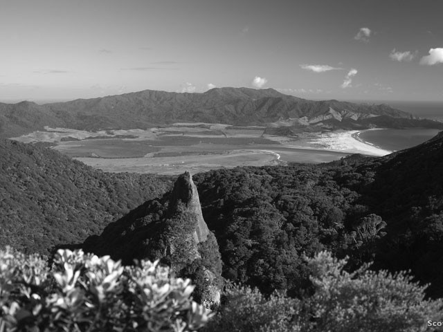
On our return to the airport we followed a track into Windy Canyon — a mountain perch that takes in the seemingly unpopulated Whangapoua Estuary region, where Helen Mabey lives, and the ocean beyond. And from this vantage point, I understood why, after a few days in the city, Mabey is so anxious to get back home.
• • •
For more, visit greatbarriernz.com, aucklandnz.com or newzealand.com. Bush and Beach Tours, bushandbeach.co.nz, operates on Great Barrier. Mountain Air, mountainair.co.nz. Air New Zealand, airnewzealand.com, flies three times weekly between Vancouver and Auckland.


