
About 2,000 people, one-third of the Nisga'a population, died in two villages in what is now northwestern British Columbia as a result of the Tseax eruption in about 1780. The catastrophe produced enough molten rock to smother the surrounding landscape, sparking raging fires in the lush forests, forever changing the course of the Nass River.
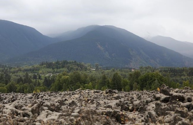
The lava has long solidified into a massive, metres-deep rocky bed. The result of the geological drama that was Canada's last volcanic eruption is today one more awe-inspiring vista in a province where superlatives ultimately fail.
B.C.'s unsurpassed opportunities for boating, fishing, hiking, biking, swimming, skiing, photography and wildlife spotting make it an internationally recognized destination. But seeking out the lesser-known wilderness of northwestern B.C. while hugging the Yellowhead Highway means discovering enchantment, history and the eye-opening pleasures of vistas imbued with Indigenous culture.
"The draw of British Columbia is nature, wildlife and culture," said Deklan Corstanje, with the regional district of Kitimat-Stikine in Terrace. "With northwest B.C., we have those things (but) they're just a little less filtered. It's a little bit more authentic. Everything is a bit bigger, a bit more raw, a bit more natural. You're not fighting for space."
The 179-square-kilometre Nisga'a Memorial Lava Bed Park, or Anhluut'ukwsim Laxmihl Angwinga'asanskwhl Nisga'a, in the Nass Valley is considered sacred territory. Locals tell the story of tourists who defy entreaties against taking a piece of rock as a souvenir, only to return it when the spirits of the dead complain.
Beyond the lichen-covered lava, the road crosses the Nass by way of a bridge with a totem at each abutment into Gitwinksihlkw or Canyon City, a village settled in the wake of the volcano. In the community, visitors hold their breaths as they walk over the river on a heaving 130-metre suspension bridge, once the only way to enter and exit the village.
Everywhere, soak in an age-old culture expressed through majestic totem poles, interpretative signs, museums and visitor centres that retell both history and legend.
The lava beds, between Terrace and the Alaska border, are but one part of an area whose splendour includes moody snow-capped mountains, fjords, powerful rivers and lakes with waters of a pleasing greenish hue. All are within striking distance of Prince Rupert — a charming port city with its own stories of sea, rail and pioneering adventure.
Prince Rupert is also the start or end point of a scenic 13-hour Via Rail ride from Prince George to the east, or a spectacular 15-hour inland ferry ride from Port Hardy on northern Vancouver Island. The 500-kilometre B.C. Ferries ride through the Inside Passage passes seemingly endless scenery punctuated by picturesque lighthouses and encounters with whales, eagles and other wildlife. Reserving ahead is essential.
Near Gitwinksihlkw, sharp-eyed motorists might spot an almost-hidden attraction: a path through mature forest leading to the Aiyansh hot springs. With only basic amenities, the three pools are reminders of the area's powerful geology even as they make for a relaxing soak.
Further east lies the Gitwangak Battle Hill national historic site, where a high grassy knoll commands views of the Kitwanga River valley. The panoramic view provided almost impenetrable defences for the Gitxsan in the mid-1700s to 1800s under the warrior Nekt. Legend has it that his mother killed the Haida chief who had kidnapped her and fled back to her people with the infant Nekt, who commanded a vast trading area before dying in battle.
About 300 kilometres east of Prince Rupert, just past the Highway 37 turnoff to Alaska, lie the Hazeltons, an Indigenous economic hub over centuries. Explore the reconstructed Ksan historical village of the Gitxsan with its decorated long houses, art studios and hands-on workshops.
Nearby, experience old-town Hazelton with its restored heritage buildings, once the end point for sternwheelers plying the tricky Skeena River.
Provincial parks offer ideal starting places for exploring the region. The parks offer quiet, forested spots for tents, campers or RVs along with drinking water, latrines and sometimes hot showers. All offer access to hiking trails through splendiferous coastal forests or to rivers or waterfalls that consistently delight.
For those seeking more creature comforts, there are hotels in the larger centres, supplemented throughout by motels, inns and bed-and-breakfasts as well as private camp and trailer grounds.
"All the way from top to bottom," said Corstanje. "It's the raw beauty of British Columbia unfiltered."
If you go:
—Don't rush. Pick a few spots for extra exploration. Talk to locals. Pick up a traveller's guide at northernbctourism.com. For provincial parks, see env.gov.bc.ca/bcparks/.
—Travellers should pack rain gear, warm clothing, and sturdy footwear, especially if hiking or boating. Snow tires are a must in winters. Mid-summers can be hot.
—If planning to take the B.C. Ferries ferry between Port Hardy and Prince Rupert, be sure to book several months ahead to avoid disappointment.


