
British Columbians are being warned to brace for another season of tempestuous weather this winter following unprecedented flooding.
The Weather Network has released an updated Canada-wide winter 2021-2022 forecast that calls for a "tumultuous temperature pattern" oscillating between high impact and milder weather.
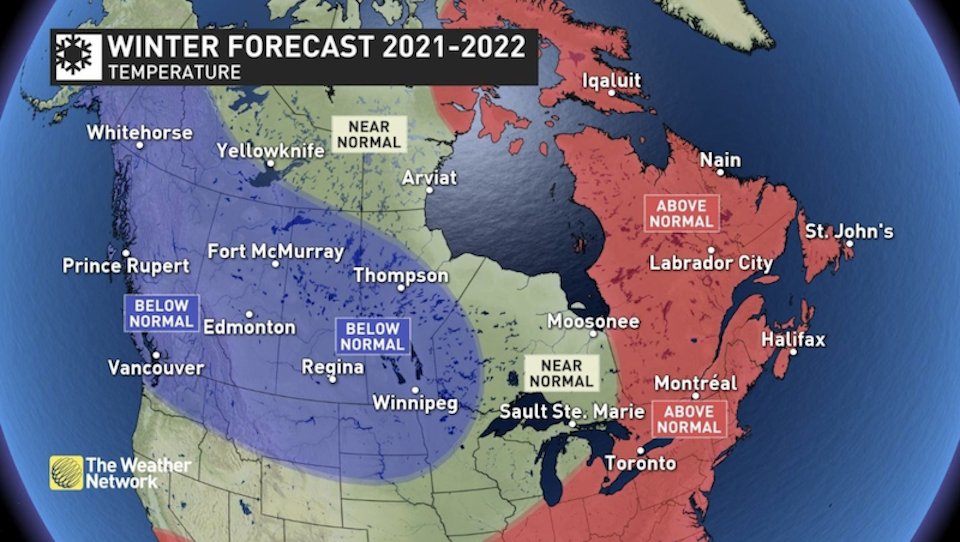
"Across western Canada, we expect that frigid temperatures will out-duel the periods of milder weather, especially during January and February," explains a news release.
For British Columbia, the forecast includes below-average temperatures during "the heart of the winter season." The Weather Network meteorologists expect that milder temperatures will surge north into eastern Canada while frigid weather will shift to western Canada.
A La Niña weather pattern in the Pacific Ocean is expected to support an "active storm track across southern Canada," which will produce above normal precipitation and snowfall for southern parts of B.C., Alberta, Ontario and Quebec.
In eastern Canada, many of these storms are expected to bring a "bring a messy mix of snow, ice, and even rain." As a result, the southern region may see below-average snowfall amounts.
Throughout the winter season, the stormy weather is expected to persist in southern B.C., bringing above-average precipitation to the region.
"This will bring an abundance of snow to the alpine regions, and at times, we expect significant snowfall across lower elevations, including Vancouver and the Lower Mainland, Victoria, and the Okanagan Valley," note report authors.
The colder than average weather is expected to dominate the season, particularly in January and February. The colder than normal temperatures may also continue into March, which could mean an extended ski season.

