
Soon, several Raspberry Shakes will be placed around the Stawamus Chief
No, this isn't a guerilla marketing move by a new local smoothie business.
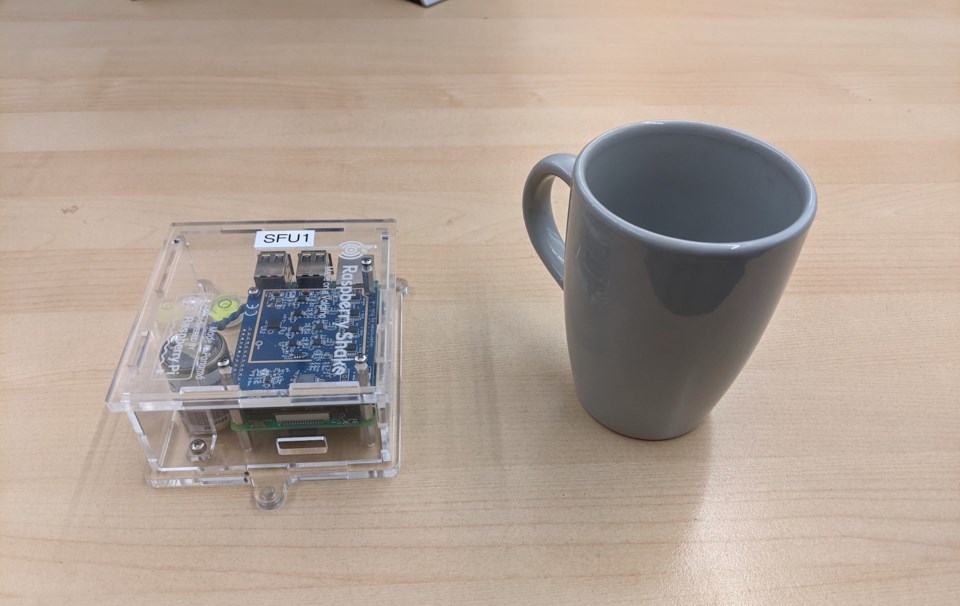
Raspberry Shakes are small remote sensors being installed to understand geological activity in Squamish regions, particularly rockfalls from the Stawamus Chief.
The sensors can detect and measure the strength of ground vibrations caused by such large events.
SFU Earth Sciences professor Glyn Williams-Jones leads the two-year "Hazard Assessment of The Stawamus Chief and the Barrier using a combined remote sensing-numerical modelling approach" project with master's degree student Ben Coughlan.
Four or five of the units will be installed in schools, ideally over the next few weeks, perhaps at Squamish Nation Totem Hall and atop the gondola, Williams-Jones said.
They are installed inside and plugged into the internet.
"These little seismometers will pick up ground vibrations from earthquakes, from earthquakes on the other side of the planet — if they are big — but also, in this case in support of this project that we are doing on the Chief, any rockfalls that come down, if we have them close enough," Williams-Jones said.
"Those vibrations will get picked up by the seismometers. So if we have four at the bottom and one at the top, then we can be comparing things that happen, and it is a way to start to build a record of how often we are getting these events.”
The sensors will stay as long as the host is willing to have them. The data will go directly to computers at SFU.
An increased number of rockfalls occurred off the Chief this summer, causing climbing route closures and leading government scientists to more closely analyze the mountain.
Williams-Jones stresses that this SFU project will not enable the prediction of rockfalls.
"We can't do that. But it will support trying to study how often [rocks] are falling. It is not something that is going to give you results tomorrow. It will give baseline information. For me, that is a key thing that we don't do enough of in Canada."
SFU Emeritus professor Doug Stead and his students have done a lot of analysis of the Chief for years — using infrared and LIDAR scans — and so Williams-Jones said he hopes this current project builds on that existing data.
"And try to better understand the nuts and bolts," he said. "Obviously, there are the clear risks to the climbers and anyone at the base of the Chief, so part of this too — we will see how the project goes.... — but thinking about better ways to visualize [the risk]. So thinking of augmented reality to show the climbers, 'OK, this area is more at risk than that area.' And try to mitigate... You can reduce the danger by better understanding where there are problems."
The Stawamus Chief is tricky, Williams-Jones said, because it is such a vertical face.
With mountains, such as Mount Meager, it is possible to sense small incremental shifts that can hint at a potential landslide.
"It is much, much more difficult with something like the Chief because of its vertical face. You get these cracks propagating in. We don't know where those cracks connect and then how it all gets to a point where eventually we have failure."
He added that what is known about the Chief is that factors like the heat dome this summer and extreme rain events are not helping things.
Other factors such as vegetation also play a role in its stability.
"Roots get into the rock and jack open cracks, which then weakens the rock further and it sets it up for instability,” he said. There's a whole lot we need to learn before we can get to a stage that we can predict the next fall. Realistically, I don't think we will ever get to that stage, but we can move toward that."
Shifting technology
A shift in the cost of technology has allowed this type of project at the Chief, Williams-Jones said.
Seismometers can be bought for about US$1,000 where the technology used to cost $20,000.
"Now you can start to do things like, 'Hey let's stick four of these things at the base of a mountain.' Otherwise, it would be a couple hundred thousand dollars with the classic type of monitoring. Here you can start to think outside the box and start to do things differently,” he said.
Williams-Jones and his team already placed Raspberry Shakes to monitor debris flows at high-risk areas on Mount Cayley near Squamish.
He ultimately hopes to expand the project to better monitor the potential for earthquakes in locations around the province.
Sensors planted around B.C.— in co-operation with community partners, who would benefit from accessing the data about their regions — would feed information into a new data portal he plans to help establish at SFU — the Canadian Natural Hazards Portal.
It is currently in development.
"The idea is to make a resource that Canadians can go to and look at data and information about natural hazards. We are trying to build a resource that is useful for the general public and useful for government and academic researchers — everyone," he said, adding data could be available in real-time.
The government does some of this type of tracking, but Williams-Jones said this portal would use citizen science and bring in other information, such as weather data.
"Bringing it in to one spot," he said. "So that people can learn and academics, smart graduate students can do neat research."
Eventually, Williams-Jones said he would ultimately like it to be something schools can use with students.
"Having a one-stop-shop for all sorts of natural hazard-related data."


