
As I scrolled through the images of the devastation along the Coquihalla Highway, what ran through my mind was, could that just as easily have been the Sea to Sky Highway?
Both highways have always been held up as marvels of modern engineering, state of the art, able to withstand all but the most extreme natural disasters. But the photos of the Coquihalla showed parts of it snapped, as if it were nothing more than a toy racetrack accidentally stepped on by Mother Nature in a tantrum.
Anyone living in Sea to Sky country is well aware that we live in a corridor of natural hazards, and indeed in decades past people have paid with their lives when disasters have struck.
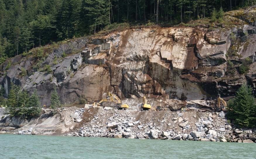
More than 18 per cent of Canada’s total landslide-related deaths have occurred along this corridor. Over the last 150 years, hundreds of landslide events have been reported. One of the most common places to see rock-fall landslides is along a five-kilometre stretch between Brunswick Point and Porteau Bluffs. “The bedrock in parts of this segment is intensely fractured consisting of meta-sedimentary, igneous, and volcanic rocks, with stress relief joints steeply dipping towards the Sea to Sky Highway,” states a report for the Geological Survey of Canada (GSC), which has mapped the whole corridor for hazards.
Indeed, rock-scaling work was ongoing there as B.C. endured the deadly atmospheric river last week that took the lives of four people in mudslides along the Duffey Lake Road, killed thousands of animals due to flooding of farmland and forced thousands of people to flee their homes.
The hazards of the Sea to Sky are well documented by experts with GSC and B.C.’s highways ministry, and Pique has reported on it extensively as well. In 2004, I delved into it for a cover feature for the newsmagazine as we prepared for the $600-million upgrade to the Sea to Sky Highway for the 2010 Olympic and Paralympic Games.
Looking back on it now, it feels prescient what Squamish engineer Frank Baumann told me then: “We can’t stop natural events but you can stop them from being disasters,” said Baumann. “That is the key thing and it is what civilized nations do.”
In 2012 he told Pique: “We seem to be going through some unusual climate changes in the sense of more rain and so forth and those are the things that can create problems.
“The mark of a civilized society is that it takes a long-term view and it makes sure that these natural hazards don’t become disasters … And we have it very much in our control to help ensure that that doesn’t happen.”
Up to $20 million has been spent on debris dams and spillways along the Howe Sound portion of the highway. And there is constant work on rock scaling too. “The Ministry of Transportation and Infrastructure, with [Miller Capilano], actively monitor and manage risks associated with the climate change,” said a ministry spokesperson by email.
“All works along the corridor now take climate change into consideration. It’s a requirement that potential impacts of climate change be considered in all transportation infrastructure engineering designs so that B.C.’s transportation infrastructure is adapted to climate changes.”
Thanks to this, the incidence of any landslides or rock fall is very small these days.
The early work was the direct result of the deaths that occurred along the highway in Howe Sound in the 1980s, and a growing realization that if you build a road into the side of a steep slope and overflowing and debris-filled creeks try to cross it, Mother Nature is going to move anything you put in her way, including houses, bridges and roads.
In October of 1981, a debris flow swept down M Creek and took out the trestle bridge around midnight on a dark, stormy, wet night. A car was on the bridge when it collapsed, and more went over the edge before the alarm was called at about 12:30 a.m. Altogether nine people died.
In February 1983, a slurry of mud, boulders and logs flowed down Alberta Creek in Lions Bay during an intense rainstorm. Snowmelt added to the disaster.
The debris flow grew in size as it moved down the channel and was probably about 10,000 cubic metres when it reached Lions Bay.
“The first surge of the flow, carrying tree trunks and boulders the size of cars and sounding like a locomotive swept through the community and into Howe Sound,” said authors and renowned geological scientists John Turner and Bob Clague in their book Vancouver, City on the Edge.
We have yet to learn the causes of the landslides that swept down across the Coquihalla Highway, the Duffey Lake Road and the many other smaller forest service roads and trails, but it is obvious that the slopes above were unstable. Was it due to recent wildfires, logging, construction, or an “act of God?” It may be some time before we have all the answers we are seeking.
But as Baumann, who sadly passed away in 2013, said, how we learn from the knowledge and take action to prevent future disasters is a measure of what type of society we live in.


