
Whistler may have avoided the flooding damage seen in other parts of B.C. during the atmospheric rivers that washed over the province in November, but behind the scenes Resort Municipality of Whistler (RMOW) staff were standing at the ready as the storms rolled in.
“I would say that there was an additional level of readiness than perhaps there would have been otherwise, given the context of what happened in the south region of the province, and also with the awareness that the River Forecast Centre may not have got it totally correct,” said chief administrative officer Virginia Cullen.
And given the unknowns surrounding atmospheric rivers, the municipality was “at a higher level of readiness than perhaps the weather, or forecast, indicated to us,” Cullen added.
“But it was a good opportunity for us to run through what we would do in the event of having a significant flood alert in front of us.”
The RMOW has two specific flood plans in place, said emergency program coordinator Ryan Donohue: a general flood hazard plan and one specifically tailored to the Fitzsimmons Creek debris barrier.
The plans provide a roadmap for the municipality when heavy rain is in the forecast, starting with a risk assessment using a flood-rating tool.
Depending on the likelihood (and severity) of a flooding event, the plans direct staff through different courses of actions to prepare.
“The final parts of those plans detail the operational components of how our staff and our resources would be deployed to respond to one of these incidents,” Donohue said.
“So it’s really a three-step process, and it starts basically from just monitoring those weather reports and getting the most up-to-date information from the River Forecast Centre and Environment Canada and assessing the likelihood of an event happening.”
Though the municipality didn’t have to fully mobilize during the heavy rain events seen in Whistler last month, roads crews were out monitoring critical spots around the community, said general manager of infrastructure James Hallisey.
“There was some low-lying pieces of Valley Trail that were under water for a few hours at a time, so some of the parks staff was engaged putting out signage and things like that,” he said.
“We definitely were keeping our eye on things … none of the forecasts made us think that we were going to have serious trouble here, but we were definitely being aware and trying to be prepared.”
NO SIGN OF INCREASED MOVEMENT ON FITZSIMMONS LANDSLIP
One major hazard looming large over Whistler is the Fitzsimmons landslip, an area on Whistler Mountain that is roughly the size of seven football fields, 35 metres thick with rock and soil.
The municipality has been monitoring the slip since 2003, recording its movements through annual surveys.
The landslip typically moves a few centimetres each year, aside from a few outlier events since monitoring began. In October 2017, for example, survey results showed the slip had moved 110 cm laterally and 65 cm vertically between October 2016 and October 2017.
A subsequent survey in the spring of 2018 showed it had gone back to its normal pace of movement, Hallisey said.
The RMOW surveyed the landslip after heavy rain on November 14 and 15 of this year, “and confirmed that it moved only a few centimetres again, like it has been for several years,” Hallisey said, adding that another survey is tentatively planned for the spring.
“We’ve done that regularly when there’s been more extreme weather events.”
It’s not an inevitability that the slip will eventually come down—“some of them just find equilibrium after a certain amount of time,” Cullen said—but a debris barrier constructed in the Fitzsimmons Valley in 2009 aims to reduce the impact on Whistler Village in the event it does.
“It was identified pre Olympics that it was a good idea to put in additional protections,” Hallisey said, adding that the province gave the RMOW ownership of the day-skier parking lots in exchange for construction of the debris barrier.
The barrier is an approximately eight-metre-tall structure made of concrete and steel that’s designed to capture rocks, logs and other debris coming down the creek.
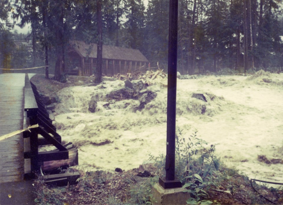
While no significant events have occurred since it was built, a debris flow in 1991 gives a sense of the potential damage.
In August of that year, a “significant amount of debris” flowed down Fitzsimmons Creek, sweeping the pedestrian bridge off its moorings on one end and undermining a bridge over Nancy Greene Dr.
“There was quite a lot of damage done within the creek channel,” Hallisey said.
“Approximately 100,000 cubic metres of debris and rocks and gravel were removed from the creek channel after that event.”
Aside from the debris barrier, the RMOW also provides flood protection via a dike and berm system along Fitzsimmons Creek (from the Gondola Transit Exchange on Blackcomb Way down to Nicklaus North Golf Course at Green Lake).
The minor movement seen on the slip after the heavy rain last month offers reassurance to the RMOW.
“Big weather events and increased movement with the slip aren’t necessarily correlated; we haven’t seen that,” Cullen said.
“I would say we’re always cautious, [and] wanting to understand what’s going on around us. We definitely were heads up on what could be moving, but we’re happy to see that we didn’t see any big movement after that big storm.”
EVERYONE ENCOURAGED TO SIGN UP FOR
WHISTLER ALERT
Whatever heavy rain or flood events may occur in the future, the RMOW feels well prepared.
In regards to both its general flood hazard plan and Fitzsimmons Creek, “we have done a lot of work over the years, and there is a pretty robust system in place,” Hallisey said.
“[Donohue] and his team have put together some great plans for what we will need to do if we need to do it, so we feel pretty well prepared for that.”
For his part, Donohue stressed the importance of signing up for WhistlerAlert, the municipality’s mass notification system.
“That will allow us to provide real-time emergency information to people, and give them a heads-up warning,” he said.
About 46 per cent of Whistler’s resident population has signed up so far, “which is fairly good for a system of this kind,” he added.
“Obviously our focus has to be on how we capture the visitor population as well, so once we get to that stage where we’re fairly confident with resident signups, we are starting to now come up with ways where we can push this information out to visitors.”
Residents and visitors can find more info and register for the system at whistler.ca/whistleralert.
“It’s been tested, it works,” Donohue said. “We’re quite confident that we’ll be able to push that information should the time come.”


