
The Squamish-Lillooet Regional District (SLRD) has extended an evacuation order for eight properties in Area C after a geotechnical review found a debris flow event to be “imminent” in the area.
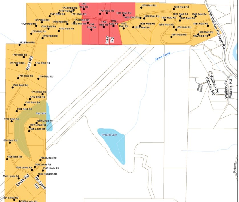
The affected properties are all located at Jason Creek in Birken on Reid Road, numbers 1781, 1791, 1793, 1815, 1782, 1788, 1794, and 1802, and will remain on the existing evacuation order originally issued Dec. 1 until further notice.
After a series of extreme weather events in November and early December, the SLRD commissioned Cordilleran Geoscience to carry out an assessment of the Jason Creek watershed, which found “imminent threat” of landslide.
“The life safety of our residents is our top priority,” said SLRD chair Jen Ford in a release. “Our hearts go out to the residents impacted by this disaster. Being evacuated from your home for any length of time is awful. These residents are facing a longer period out of their homes, especially difficult during the holidays. We can only imagine how hard this is on the families affected. Returning is just too dangerous. A debris flow event, with not just water, but boulders and trees, is assessed as being imminent, and of a volume that could result in loss of life, and that is a risk we cannot take.”
The SLRD said the upper fan of Jason Creek is now vulnerable to a further, highly-destructive landslide event that “could result in severe property damage and the potential for injury and loss of life.” The report noted that instability at higher elevations was increasing in size and there is an imminent landslide hazard.
All the affected homes are now evacuated.
“We have had ongoing communications with the affected Reid Road community since the first Evacuation Alert was issued on December 1,” said Ford. “We advised them that we had commissioned the report, which we have now shared with them, and will work with them in the coming weeks and months to support what will be a complex recovery process and longer-term needs.”
The next step now is to undertake a peer review of the geotech report to confirm its findings, further refine the risk assessment, and determine the scope and feasibility of mitigation measures. That is expected for completion by the end of next month.
The SLRD is working with the Canadian Red Cross to offer “medium-term” support of evacuees, and is also looking to appoint a dedicated recovery manager to assist in long-term recovery, including liaison and advocacy with the applicable agencies.
The regional district has requested any mitigation options, if possible, to be scoped, and a basic cost estimate of these measures will help in future consultation with the community, it said.
“As we’ve seen in other parts of the province, this has been an unprecedented year of natural disasters, in part the result of climate change,” said Ford in the release. “Climate change is moving fast, and we have to adapt to it, but we need the help of the Provincial Government. These residents are at risk of falling through a gap in the disaster financial assistance provisions, because their houses are not damaged but cannot be occupied, and this is an uninsurable risk. The SLRD has no way to directly fund this kind of assistance and we hope to find solutions with the Provincial Government to support citizens impacted by dynamic changes in risk levels from natural hazards, influenced by climate change.”
The SLRD will also erect security and signage in place for the security of the evacuated properties, and to warn the public of the hazard.
Residents with questions can contact the SLRD at 604-894-6371 or [email protected].
The geotechnical report is available to view at slrd.bc.ca/JasonCreek_ReidRoad.


