
More multi-generation family members joined the annual Wedgemount Glacier survey on Sept. 3, and confirmed that the glacier is receding at alarming rates. This year, second-generation researcher Rob Tupper, our key surveyor, brought his daughter, Brooklyn, along with boyfriend Liam—both University of Victoria students in earth and ocean sciences, and that spells great surveys to come. Another second-generation researcher, Dave Lyon, was accompanied by his daughter, Rebecca, and an exchange student from Germany, Florentina. Kristina Swerhun organized the operation at the glacier.
One focus of this year’s survey was to map the depth of the now fully emerged Tupper Lake, located about 350 metres up the valley from Wedgemount Lake and at an elevation of 1,910 metres, or 50 metres higher. The glacier recession from lake to lake was over uneven, rocky ground, but it is surprising how foot traffic has generated a trail between the two.
Tupper Lake is so named after the instigator of the Wedgemount survey beginning in 1973. Bill Tupper was a photogrammetrist (meaning he used photos to help survey), teaching the topic at B.C. Institute of Technology (BCIT). He passed away in 2005. His son Rob, a survey engineer, is now carrying the torch.
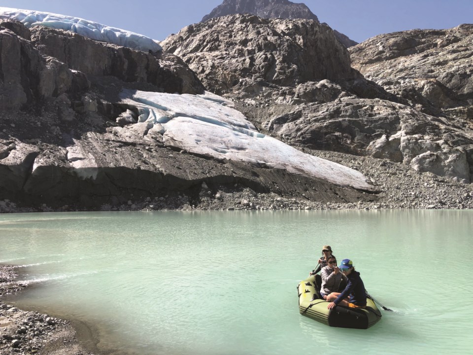
The first task upon arrival was to take depth measurements of Tupper Lake from an inflated raft. One hundred measurements on about four hectares of lake surface provided a max depth of 12.5 metres.
Meanwhile, Dave and assistant, Bronwyn, hiked up the steep rock rubble to the present glacier terminus on the crest of a cliff band to build a new cairn/monitoring station, revealing eight metres of horizontal ice retreat over the year. The rise from the lake to the cairn is 63.7 metres, indicating a very abrupt step up in retreating ice from 2020 to 2021. The plotted bathymetry (depths) will provide a volume of water in Tupper Lake.
Next, Rob hiked onto the ice to locate a BCIT station from 2020. Once found, it revealed significant thinning of the ice (surface ablation). In two years, the height of the ice had diminished by 5.7 metres—a surprising amount given the high elevation of ice which now begins at 1,974 metres. The survey party then descended to Tupper Lake to conduct an exact perimeter survey.
Tupper Lake underlies the former junction of the Mount Weart and larger Wedge Mountain arms of Wedgemount Glacier, with about 110 metres of ice thickness in 1977. By 2016, there were floating icebergs in the lake, but no intact glacier on it, which tells us that 39 years of surface ablation is about 2.8 metres per year.
As a final gesture for the day, the ashes of Bert Parke, one of Bill Tupper’s helpers in the 1970s and ’80s, were scattered about trig station No. 6 above the Wedgemount hut. Bert passed away in March 2022.
What is in store for the future? Glacier recession is expected to decrease to values less than eight metres per year as experienced in the 1970s and early ’80s. This is because the ice is now at a higher elevation, where it is cooler, so the annual ice melt should decline. Will this be confirmed? The new family chain of surveyors has a job to find out!
Naturespeak is prepared by the Whistler Naturalists. To learn more about Whistler’s natural world, go to whistlernaturalists.ca.


