
The trail to the Wedgemount Glacier isn’t easy.
With an elevation gain of over 1,160 metres in just six kilometres, it’s mostly straight up through the forest without a view until the alpine.
That’s why Dave Lyon was skeptical when his son, Graeme, wanted to tag along on his annual glacier-monitoring mission.
“When he was 11, I relented because he kept pestering me to head up there,” Dave says. “He started coming up and he wanted to come up every year.”
After that first taste of a weekend in the mountains alongside his dad and a group of likeminded outdoorspeople dedicated to the task of measuring the rapidly receding glacier, Graeme was hooked.
“It was my first time backpacking,” he recalls. “And then watching Karl [Ricker] do these calculations and directing the operation, that was pretty neat. It was over my head at that point. I went up every year until I was 17. It’s been more sporadic since them.”
Now a student at the University of British Columbia studying Natural Resources Conservation—inspired by his years hiking and camping—he stills tries to take part in the annual effort whenever he can.
“I loved that kind of stuff,” he says. “It’s a pretty incredible thing. It’s cool to be part of something bigger than yourself. It’s nice to catch up, too. It’s kind of about the community, being outside, getting out there.”
HOW IT ALL STARTED
Graeme is part of the third generation of Lyons to take part in efforts to monitor the Wedgemount Glacier. While there’s no official documentation, it is likely poised to be the longest-running glacier-monitoring project in the country.
It all started back in 1965, when Karl Ricker, geologist by trade, and also a glaciologist, geographer, and birder in his spare time, made an ascent of Wedge Mountain. Back then, there was no highway beyond Whistler or hiking trail maintained by BC Parks; he and his crew simply hopped in their Volkswagen and navigated as far up powerline roads as they could, with some instruction from the famous mountaineer Neal Carter, who made the first known ascent of the mountain in 1923.
After making their way to the peak, “we noticed this lake with a glacier flowing into it on the north side of the mountain,” Ricker recalls. “The map we had showed no such lake. We thought, ‘Well this is interesting.’”
(Keep in mind, while the lake the glacier directly flows into these days is unofficially named Tupper Lake, back then the glacier actually extended further down to the main Wedgemount Lake—but more on that later.)
Ricker had a lot of projects underway, but the desire to further investigate that glacier stuck. In 1973, he hooked up with his old mountaineering buddy, Bill Tupper, and they set out to see what they could find.
While the mission allowed them to confirm the glacier was certainly there, flowing into the lake, thick fog made it difficult on that trip to do any measurements.
“We hiked our way to the top of Mount Weart,” Ricker says. “Everything below us was still in the clouds. We couldn’t do angle measurements.”
In the spring of 1975, they decided to try once again and ski-tour up to the glacier with some friends.
“The lake was frozen over, so with climbing ropes, we measured the distance from the glacier to the west end of the lake,” he says. “That was the start of our monitoring at the lake. We went back with equipment every year thereafter—Bill and I, and Don Lyon being one key friend. We went and did our work on Wedgemount.”
For his part, Bill Tupper taught photogrammetry, which uses photography for surveying and mapping, at BCIT in Vancouver, so the project put his expertise to use.
Like Graeme Lyon, Rob Tupper, Bill’s son, first went up to help with monitoring weekend when he was just 10 or 11, with a young Dave Lyon also in tow.
“I didn’t understand the significance, but I understood the legacy of this group of friends who had met in the Rockies and were part of the Varsity Outdoor Club—their contribution to B.C. and Canadian mountaineering was significant,” Rob says.
In 1986, Bill received some grant money to take a helicopter to the summit of Wedge in an effort to replicate the first known photograph of the area in the 1920s. “He wanted to try to recreate the same photograph with the same methodology to contrast the 1920s and the 1980s,” Rob says.
In prior years, though, Bill would sometimes bring his students and even colleagues up to help—something that’s continued on and off to this day.
Rob remembers his role as a little more basic. “We were probably given the end of the tape measure to do something rudimentary,” he says. “It was a family endeavour, I guess would be the best way to put it.”
That wound up being doubly true when he brought his daughter Ellie, who’s in Grade 12, up to help with the monitoring this past year. (He hopes to bring his older daughter, Brooklyn, up some day as well, but she’s at the University of Victoria studying earth sciences, which makes logistics tricky.)
“Ellie loved it,” he says. “She got to ride in the helicopter with Karl. She would’ve made the climb but the seat was available. Karl has a way of bringing people in and having them be involved. No one gets left behind.”
(This might be a good time to bring up the fact that Ricker, who is 85, most recently made the gruelling hike up at 80 years old. Since then, he’s been helicoptering up, but awe seems to be the standard for his long-lasting fitness.)
“As I got older, I was more interested in what they were monitoring,” Ellie says. “I thought it was really neat what they were doing. It’s cool to carry on a tradition started [in part] by my grandpa and be the third generation of Tuppers up there.”
While Rob—who grew up to be a surveyor, offering his professional skills to the project like his father, living for nearly two decades in Vernon—aimed to make it for the trip at least every second year, depending on family, work, and travel, it wasn’t until after Bill’s passing in 2005 that Dave became extra devoted to the yearly task.
He recalls first going up as a teen in 1979. Ricker remembers in the early days Dave once pushing a measuring wheel during the hike up while his dad nailed kilometre markers to the trees.
“I remember being very impressed with it. I don’t think anyone ever forgets the trail up there,” Dave laughs. “The monitoring of the glacier appealed to me, but I was moving into a point in my life when things got very busy. I graduated, went to university, travelled, got married, had kids.”
His next trip back up was in 2006.
“I came back to it after Bill passed away,” he says. “I went to his funeral. Obviously my mom and dad were there, his wife was there, [his sons] Ken and Rob. It got me thinking—this was a neat project. That generation was getting old back then, let alone now. I remember thinking, ‘If we want this to carry on, we better be prepared to carry the baton or carry the torch to help support carrying it on.’”
BEARING WITNESS
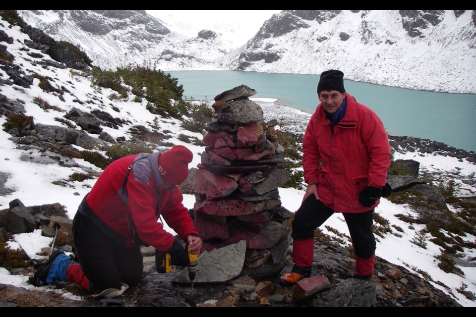
Anyone who has hiked to the glacier, which is another 30 minutes or so from the small hut overlooking the lake, over multiple years can tell you the value of measuring—and simply witnessing—its spectacular journey back up the mountain.
In September 2020, monitoring revealed that the glacier had receded 30 metres since 2019—that’s almost five metres more than the 10-year average. That’s in addition to the 585 metres—more than half a kilometre—it has receded since monitoring first began.
“I’d like to see it keep going in one way or another,” Ricker says of the monitoring effort. “I don’t want to see it become a satellite exercise, strictly. That would be painful for me. Ground control is essential in all of these surveying projects.”
That might be true from a logistical standpoint, but also the idea of generations of families and friends bearing witness to this disappearing glacier also feels somehow essential—and poignant.
“I think there’s a legacy to it,” Rob says. “There’s something tangible when you’re there with a compass taking basic measurements … and doing something constructive and writing it down and having that be a legacy.”
Ricker took it into his own hands to give Bill Tupper his own unique legacy when he started calling the new lake—first recorded in 2013—at the bottom of the glacier Tupper Lake. (Over the last seven years, the body of water has grown by about four hectares, increasing 18 per cent since 2019.)
“It’s not an official name,” Ricker says. “It hasn’t been approved by official authorities … We had to do something for Bill to commemorate his great efforts and the 10 to 15 years he spent on the project. He was a natural.”
While Rob thinks the gesture would’ve made his dad smile, “he probably would say, ‘It should really be named Ricker Lake.’ Those two had mutual admiration for each other.” (As a side note: national authorities no longer allow the naming of geographic features after living people.)
Bill wouldn’t be alone. Everyone involved in this project has admiration for Ricker’s longstanding dedication and passion. While he tentatively announced his “retirement” from monitoring after last year’s trip, he doesn’t seem entirely sold on the idea.
“I’m 85 years old,” he says. “I’m not going to last forever … I’ll go as long as I can do it—as long as I can get a helicopter ride.”
(Kristina Swerhun, also involved in the monitoring, and the Whistler Naturalists alongside Ricker, has helped organize that ride the last several years through funding from the Whistler Community Foundation. Everyone involved also heaps praise on her effort and commitment.)
Practical value aside, the project has also tied the Tuppers and Lyons to each other and their fathers’ mountain adventure friend for decades.
Whether that September weekend saw them huddled in the tiny cabin riding out a violent storm, enjoying the alpenglow on the peaks around them, or weathering a snowstorm (then attempting to find the edge of the snow-covered glacier), it was always a time to come together in the mountains.
“Karl is a special guy and he’s got a passion for this. I’m going to get emotional,” Rob says, pausing for a moment. “These guys had this idea [nearly] 50 years ago. It was a different era. They came up with this idea and it’s not insignificant what they did. When you see the change in the glacier from the mid-1970s until now, it’s stunning.”
.jpg;w=120;h=80;mode=crop)

