
Glacier monitoring has a long history in the Whistler area. Karl Ricker has been monitoring Wedgemount Glacier for 46 years, a project instigated by Bill Tupper that also included Don Lyon on the original crew. The crew's first sighting of Wedgemount Glacier was from Wedge Mountain in 1965, when the glacier was floating on Wedgemount Lake.
Over the last 46 years, the glacier has steadily receded over half a kilometre—585 metres. Yes, "our" glaciers are part of the worldwide recession. As Wedgemount Glacier continues to recede, a new Tupper Lake at its terminus continues to enlarge.
Why monitor glaciers? Glaciers grow and shrink in response to changing climate, so their movement marks changes. Monitoring data can be analyzed to determine the causes of recession—was it low snowfall, summer temperatures or a combination of factors? The data also allows researchers to assess ecological and hydrological effects on species (including humans) living in the area or downstream. Finally, researchers can use the data to predict future changes and effects—like how much shrinking glaciers will affect water availability.
The survey of Wedgemount Glacier this year was on Sept. 20, as two long weeks of wet weather precluded an earlier visit—this is becoming an annual delay. The field party of four consisted of Kristina Swerhun, Dave Lyon (son of original crew member Don Lyon), Doug Wylie and Karl Ricker. Unfortunately, Rob Tupper (chief surveyor and son of original member Bill Tupper) could not attend.
As recession of Wedgemount Glacier continues from Wedgemount Lake, uphill to an obvious rock hump (exposed fully by 2005), and to a new smaller lake basin at glacier terminus (beginning to develop in 2013), we are now seeing a much steeper glacier surface. On the other hand, the northwest arm of the glacier located under Parkhurst Mountain is nearing full disappearance with another new lake below it.
This year's recession (horizontal) was only 12.8 metres, as opposed to the 30-plus metres of recent years. Why? Most of the terminus is no longer submerged in the buoyant and warming influence in Tupper Lake, although the skier's right terminus, fully exposed to the sun, has drawn back about 46.7 metres (we ignored that for reporting purposes).
Tupper Lake expansion is now to 3.4 hectares (or approximately seven football fields), but an appearing rock bluff wall will reduce further enlargement. It needs a depth survey, known to be more than nine metres.
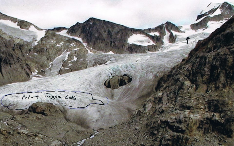
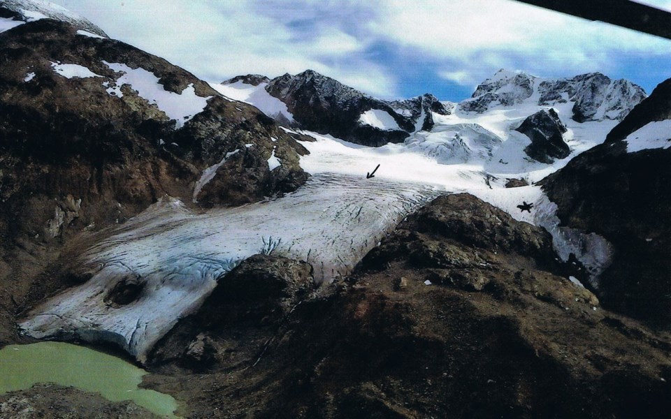
Another facet of glacier monitoring is the location of the equilibrium line—where bare ice meets year-round snow cover. As the line rises in elevation with the procession of ever-warming climate change, so does the terminus of the glacier recede. It is a more or less direct coupling effect. Photo 1 taken of Wedgemount Glacier in 2005 shows it to be at the upper icefall—definitely an unhealthy position. For 2019, however, Photo 2 shows the line well below the upper ice fall bordering the intermediate crevasse zone at about 2,150 metres—a cooler summer!
Overlord is another glacier that started being monitored in 1986. On that first visit, it was revealed that the glacier advanced since 1951, a worldwide phenomenon with many glaciers. The 2017 survey of Overlord Glacier showed that recession over 27 years was 264 metres. It's interesting to note that over the same time span Wedgemount Glacier receded 472 metres. Why the difference in two glaciers in such proximity? It could be a myriad of things and shows just how complex glacier science is. Unfortunately, the Overlord Glacier survey was again missed this year, but it will be a priority mission in 2020.
After 46 years of surveying, Karl is near retiring and will be handing off these two projects to a younger generation of researchers. The contribution Karl has made to our understanding of the natural world is unmatched. He has explored the mountains, valleys and regions around Whistler perhaps more than any other person alive. A remarkable naturalist, Karl has not only contributed glacier monitoring data, but has also studied the flora and fauna of our region. He has contributed in huge ways to our knowledge of the animals and plants that inhabit and surround our community. He has been a tireless advocate for responsible development and sustainable practices that protect these spaces. Thank you, Karl!
NatureSpeak is prepared by the Whistler Naturalists. To learn more about Whistler's natural world, go to whistlernaturalists.ca.


