
During the disastrous flood of record that wreaked havoc in Pemberton in October 2003, flow rates on the Lillooet River peaked at about 1,490 cubic metres per second.
The June 2021 heat dome, meanwhile, saw the river’s flow rate sit above 600 m3/s for six consecutive days. Still, the event managed to cause significant flooding, mass sandbagging efforts and even evacuation orders in the area.
Basically, the Pemberton Valley’s risk of suffering the adverse effects of flooding is going up, even if the river’s flow rate doesn’t, explained Veronica Woodruff, senior project manager and principal with Clear Course Consulting and founder of the Pemberton Stewardship Society. “You’re seeing the flood levels be much higher at a lower discharge,” she said.
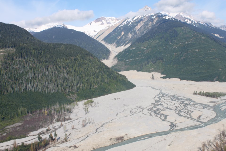
One reason for that? A 12-and-a-half-year-old landslide debris field on nearby Mount Meager.
The entire southern peak slid down the side of the volcano in August of 2010, bringing an estimated 50 million cubic metres of debris down onto Capricorn Creek and into the Lillooet River Valley along with it. It’s considered to be the largest landslide ever recorded in Canada. Sediment from the remaining four-square-kilometre debris field has been slowly but steadily working its way into the waterway ever since.
The Pemberton Valley Diking District has been working to remove that sediment from the river annually in an effort to maintain its capacity to handle high-water events, Woodruff explained. “They take up to 60,000 cubic metres [of gravel] a year,” she said. “That’s quite a lot—I think that’s like 6,000 dump trucks.”
That work is typically carried out in February or March, when water levels are low, she continued. The problem? “Usually by September, October, that gravel they’ve removed is already back,” she said. “It’s not a long-term solution and it has to be done every year, otherwise that flood risk is even higher.”
Floodplain mapping suggests erosion off the landslide debris could continue for decades, but Woodruff has an idea that might just clear things up in a shorter timeframe: ecologically restoring the site.
“One of the ways to reduce erosion, when you look at a site like landslide debris, is to have a working ecosystem—so trees that hold all the sand and gravel in place,” she explained. “That was our idea to not only improve habitat at the site, because it is still quite devoid of vegetation, but to reduce the amount of sediment that’s moving down the river.”
Last month, the restoration project Woodruff helped spearhead alongside Lil’wat Nation’s Troy Bikadi in 2019 received $150,000 from B.C.’s Community Emergency Preparedness Fund. The funding is provided by the provincial government and administered by the Union of BC Municipalities, intended to support communities to better prepare for, mitigate and respond to climate-related emergencies.
The funding will pay for engineering and geomorphology input needed to assess the landslide debris field and develop a planting plan, said Woodruff. “Those kinds of professionals are just generally expensive,” she explained. Plus, “what we learned in 2021 is that it’s actually not as simple as planting trees,” she added.
During 2021’s heat dome, researchers were confronted with just how unconfined the flow of Meager Creek is through the slide debris, particularly during flood events.
“The stream just goes everywhere,” Woodruff said. “So if we planted trees … and then you have a high event like in 2021, basically, the water would have wiped everything out.” With that in mind, project leaders are considering a few ways of managing the reforestation area.
“One of the ideas is, potentially, to build a setback berm that would exclude Meager Creek from accessing a portion of the slide debris that we can work on to restore,” Woodruff said.
Work could include “really innovative restoration techniques” like incorporating different species of plants and shrubs, conducting ground treatments or even introducing mycelium.
Woodruff was on hand during an event at the Ullus Banquet Hall in Mount Currie on Thursday evening, Feb. 23 to discuss the newly-funded project, alongside Glyn Williams-Jones, a volcanologist and Earth sciences professor at Vancouver’s Simon Fraser University, who presented his seismic research findings at Meager to an audience of about 40.
That raises another question: what happens to the ecological work in the event of another incident on the notoriously unstable massif?
“There’s so much uncertainty when you’re looking at risks like volcanoes,” said Woodruff. “Like, ‘is it going to erupt?’ or, ‘Is there going to be another landslide?’ The truthful answer is I have no idea.
“Meager is Canada’s most active volcano, but it is still considered dormant. The risk from a volcanic eruption at Meager is incredibly low probability, but of course high consequence—and not only for our site.”


