
Avalanche Canada has added a new tool to its reporting repertoire.
The Mountain Information Network (MIN) is now live on Avalanche Canada's website and mobile app.
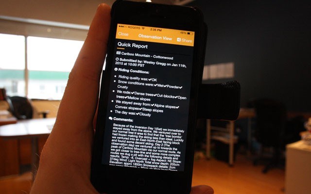
The MIN allows backcountry users to share information about weather, snowpack and avalanche conditions — all in real time.
"The whole idea here is to start getting an information exchange going amongst backcountry users, much like the professional information exchange that goes on that we use to produce our forecasts," said Karl Klassen, manager of Avalanche Canada's public avalanche warning service.
While the MIN hasn't been live for long, Klassen said Avalanche Canada hopes the user base will grow.
"We're looking at (there being), potentially, thousands of users," he said.
"We hope it will have broad appeal, both in the recreational community and perhaps also in the more advanced-user community — people with training and experience and background."
And somewhere down the line, Avalanche Canada hopes to upgrade the capabilities of the MIN to allow users to easily share more detailed and technical information.
"Right now it's still what I would call a basic or relatively simple version of info exchange. It doesn't allow highly detailed info to be exchanged easily," Klassen said.
"We're looking for funding right now to fund the final phase of the project."
Submissions to the network are geo-tagged and appear on the app's map as small blue dots that users can tap or click to view the submission.
Users can also add photos or text comments to their submissions.
But with users being able to post information without moderation, is there concern that backcountry enthusiasts might be misled?
"We've talked about that — if we should moderate that information before it can go — but we don't really have a way of validating the information," Klassen said.
"We would have to be calling people and sending somebody out there to say, 'oh yeah, that looks right,'... that would really slow down the information exchange. We're trying to make this as real time as possible."
The MIN will help fill in the gaps of some of the under-reported regions in the country, Klassen said, but it shouldn't be relied on as the sole source of avalanche information for backcountry users.
"I would caution people not to rely on any single piece of information to make a decision about whether to ski or ride on a slope or not," Klassen said.
"So you start with the avalanche forecast, which gives you the big picture, you look at the data that's being submitted from the field, which gives you local data from a certain point at a certain time, and do all the research that you've always done in the past... this is just another piece of info that you should be adding to the larger puzzle."
The Avalanche Canada app can be downloaded from the iTunes or Google Play app stores.
Before heading into the backcountry, users should check Avalanche Canada's website at www.avalanche.ca for up to date conditions.
Whistler's conditions can be found at www.whistlerblackcomb.com/the-mountain/backcountry/avalanche-advisory.aspx.


