
Looking to spend more time in the alpine this summer? If so, the Resort Municipality of Whistler (RMOW) has some good news for you: Its alpine trail network on Mount Sproatt and Rainbow Mountain is officially open for the summer, the RMOW announced in a release on Thursday, July 15.
So what's new for the trail network this year?
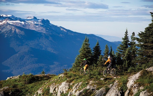
Firstly, two new mountain bike trails on Mount Sproatt, dubbed Rush Hour and Last Call.
According to the release, Rush Hour leaves On the Rocks, descending through "numerous rock slabs" to Squirrel Pass. Riders then climb Happy Hour, as in the past, to Sproatt and the Valley Overlook.
The second new trail, Last Call, "descends through alpine lakes, tarns and more rock slabs" before returning to Squirrel Pass and continuing back up Happy Hour to Squirrel Lake.
Also new for 2019 is an expanded Mount Sproatt/Rainbow Mountain Alpine Ranger Program, which will see rangers "now on-site for more hours and more days."
Rangers' responsibilities include monitoring and maintaining trails, public education, collecting data on wildlife and recreation users, and administering first aid when necessary, as well as communicating with RMOW staff and partners, like Conservation Officer Service, Search and Rescue and provincial biologists.
Dogs will be prohibited from all Sproatt and Rainbow alpine trails, as will e-bikes. In accordance with Whistler's recently released draft e-bike policy, the electronic bikes are not allowed access to the Sproatt alpine trail network above Flank Trail. As in previous years, bikes will not be permitted on Rainbow Lake or Skywalk hiking trails.
To access trails located above Alpine Meadows-including Skywalk, Cultured Climb, Rick's Roost, Green Monster, Flank Trail North, Howler and Screaming Cat Lake-users are asked to park at the Meadow Park Sports Field parking lot, accessed from Camino Drive, or to take public transit, which will bring users closer to trail access points.
Following complaints about trail users parking near Alpine Meadows trailheads, the release reminded "to be respectful of residents when accessing trails from residential neighbourhoods. Bylaw enforcement is in effect."
It also reminded trail users to follow AdventureSmart principles before heading out. "The Alpine Trail Network provides a backcountry experience that requires a high level of fitness and preparedness for a day-long bike or hike in remote, strenuous and alpine conditions," read the release. "Ensure bikes are well-tuned, and pack spare parts, food, water and appropriate clothing for changing weather conditions. Be prepared for self-rescue."
To that end, the municipality is also urging users to respect the trail network's "sensitive alpine vegetation" and to "stick to the marked trails to avoid damaging the environment."
Because the Rainbow Lake trails are located within the municipal water supply area, camping, biking, swimming and dogs are not permitted in this area in an effort to protect Whistler's water supply. "In all areas, pack out all garbage, use outhouses, take only photos and leave no trace," added the release.
Trail users should also keep in mind that grizzly and black bears can be found in the Whistler area-including near the Alpine Trail Network.
"All trail users should be bear aware by carrying bear spray and knowing how to use it in the event of an encounter, never hiking or biking alone, being alert to bear signs (scat, prints, tree markings), being able to differentiate between grizzly and black bears, and respecting trail closures," stated the release.
The RMOW is currently developing a plan to help mitigate potential conflict with grizzlies on its alpine trail network. The province decided to close the trail network last September after two separate groups of hikers has a close call with a grizzly near Rainbow Lake.
Though there is signage and cell phone coverage along most of the trails, all located on the west side of the valley, hikers and bikers can find updated maps of all the RMOW's official hiking and mountain biking trails at trailheads and online at trailforks.com, or by downloading detailed maps for Mount Sproatt and Rainbow Mountain.
Funding for the program to restore and develop the Alpine Trail Network has been provided through the Province of British Columbia's Resort Municipality Initiative (RMI).
For more information, head to whistler.ca/alpinetrails or contact [email protected].


